Moderate sized swells continue with a window to the east
Victorian Surf Forecast by Craig Brokensha (issued Monday 17th July)
Best Days: Today, tomorrow ahead of the change, Wednesday all locations (afternoon to the east), Friday, Saturday
Features of the Forecast (tl;dr)
- Slowly easing mid-period swell tomorrow with strengthening N/NW tending NW winds, W/NW early PM ahead of a mid-PM SW change
- Moderate sized mid-period SW swell for Wed AM, easing
- NW tending NE winds on the Surf Coast Wed, W tending variable NE to the east
- Fading surf Thu with strong N tending N/NW winds late
- Moderate sized mix of mid-period and inconsistent W/SW groundswell Fri, peaking into the evening, easing Sat
- W/NW winds Fri, strong N/NW tending W/NW Sat
Recap
Saturday started slow but fun with some new mid-period W/SW energy to 2-3ft on the Surf Coast ahead of some stronger swell energy building into the afternoon.
Yesterday was the pick though with some stronger, sizier SW swell filling in, offering building surf to 4-5ft through the day on the Surf Coast, bigger and bumpier to the east.
This morning the swell is is on the slow decline with clean 4ft+ sets persisting on the Surf Coast, 6ft+ to the east with lighter, more favourable winds. Winds should hold out of the N/NW-N all day as the swell continues to ease.
This week and weekend (Jul 18 - 23)
We'll see the size continue to ease through tomorrow across all locations, though only slowly thanks to persistent but unfavourably aligned frontal activity through our swell window behind the strong low linked to yesterday's increase.
The Surf Coast should still be around 3ft+ with 4-5ft+ waves to the east, with the morning being the pick under strengthening N/NW tending NW winds, shifting W/NW early afternoon ahead of a mid-afternoon SW change.
Some small, localised mid-period SW swell will be generated by this relatively weak front bringing tomorrow's change, peaking Wednesday morning to 3ft+ across the Surf Coast and 4-6ft to the east.

Conditions may be a little lumpy early but improving with a light to moderate NW breeze, tending NE into the afternoon while to the east we'll see W'ly tending variable and even NE winds. This should create improving options across exposed beaches into the afternoon, with Thursday becoming very tricky thanks to strong N'ly winds, shifting N/NW later afternoon and a small, weak, easing swell.
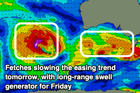
The strengthening northerly winds will be thanks to a strong mid-latitude frontal system moving in from the west, weakening on approach to us and pushing through into the evening.
This frontal system is currently in the form of a significant low pressure system to the west-southwest of Western Australia, with it generating a fetch of gale to severe-gale winds while moving slowly east. It's expected oo weaken and split on approach to Western Australia, resulting in an inconsistent but strong W/SW groundswell for Friday that's due to build through the day and peak into the evening.

There'll also be some mid-period energy in the mix from the front pushing through into the evening Thursday
Size wise, the Surf Coast should build to the 4ft range through Friday afternoon with 6ft+ sets to the east and W/NW-NW winds will create clean conditions all day on the Surf Coast.
Winds look a little more N/NW Saturday morning as the mix of swells ease from a similar size range.
Longer term some fun new mid-period W/SW swell is due early next week ahead of a moderate sized + W/SW groundswell Tuesday, generated by a significant storm in the southern Indian Ocean. More on this Wednesday.


Comments
Its pumping out there Craig bigger than 6 on the sets with a lot of water moving.
Nice, 6ft+ on the exposed beaches eh?
Yeh today significantly better than yesterday on size, shape and consistency, farkin scored yewww
Secret spot this morning. Was inconsistent 4-6ft imo, got a few crackers!
How are the conditions!