Generally slow week, picking up into the weekend
Victorian Surf Forecast by Craig Brokensha (issued Monday 3rd July)
Best Days: Beaches today and tomorrow, beaches Thursday, protected spots Sunday/Monday
Features of the Forecast (tl;dr)
- Small-moderate sized inconsistent groundswell arriving late today, peaking this evening, easing steadily tomorrow
- N tending N/NE winds to the ease tomorrow, N/NW-NW tending N/NE to the west
- Small Wed with N/NW-NW tending N winds
- Inconsistent moderate sized W'ly groundswell Thu with strong N winds
- Easing surf Fri with NW winds
- Large W/SW groundswell for Sun with developing strong W/NW winds, easing a touch Mon with gusty W/NW winds
Recap
Saturday morning offered a window of light winds and weaker than expected onshore breezes elsewhere with a temporary drop in swell to 3-4ft on the Surf Coast before building back through the afternoon with a good pulse of new mid-period SW swell. Yesterday morning was a touch cleaner as the swell started to ease back from 3-4ft, average to the east.
The swell has continued to ease back quite a bit overnight leaving slower, clean 2ft waves on the Surf Coast and 3-4ft sets to the east with much better conditions. Winds will remain favourable for the beaches all day as the swell continues to drop. There's an outside chance for some new long-period groundswell on dark, discussed in more detail below.

Still some size across the opemn stretches
This week and weekend (Jul 4 - 9)
Looking at tomorrow and the swell magnets are the go across the state as a late pulse of SW groundswell due this evening, peaks overnight and eases quickly through the day.
The source of was an off axis but strong fetch of gale to severe-gale NW winds to the south-west of Western Australia last Friday and this should provide 2-3ft sets overnight on the Surf Coast and 4-5ft sets to the east, backing off from dawn tomorrow.
So in general we may see a few stray sets to this size early, before easing steadily through the day.
Winds look to be be NW to the west and N to the east tomorrow morning, shifting N/NE through the day, with a shift in winds to the N/NW-NW Wednesday morning, N'ly arvo to the east but with the swell bottoming out.
We then look at the first in a series of westerly swells due through the forecast period, with a very healthy and impressive progression of strong frontal systems due to migrate from the Indian Ocean, east under the country through this week and next.

What this will result in is an overactive period of swells with favourable winds for the Surf Coast, ebbing and pulsing between the moderate to large size range.
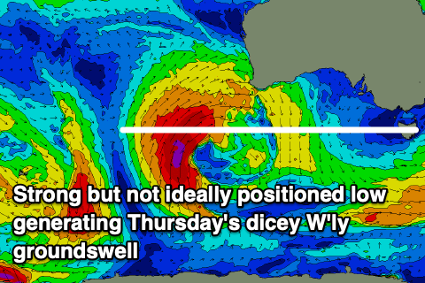
Looking at Thursday's swell, and a strong low that's currently sitting south-west of Western Australia is generating a fetch of gale to severe-gale SW winds that are not ideally aligned in our western swell window a little too far north.
This will make for a tricky, inconsistent groundswell but the Surf Coast should see infrequent 2ft to possibly 3ft sets with 4-5ft+ waves to the east.
Strong N'ly winds will favour selected spots on Thursday, with the swell easing through Friday as winds shift NW. So all in all not ideal.
The activity following this low is the more juicy stuff, with back to back strong fronts due to move in and under Western Australia later week, with the initial system generating strong to near gale-force W/SW winds, followed by a stronger fetch of gale to severe-gale (short-lived) W/SW winds.

This should produce a large W/SW groundswell for Sunday/Monday that looks to come in at 6ft to occasionally 8ft across the Surf Coast magnets with 10ft+ sets to the east along with strong W/NW winds developing through Sunday, gusty W/NW Monday.
The only possible small issue is that EC pushes this activity a touch further north during its final stages, so we'll have a closer look at the sizes expected through Wednesday and Friday.
Following this there's expected to be a few days of smaller, moderate sized swell ahead of another possible large episode the following weekend. More on this in the next updates.


Comments
yeww :))
Great to see this morning's SW groundswell from this fetch come in as expected.
Always quite amazing seeing swell from a NW fetch thanks to Great Circle paths and radial spread.
Craigos - looks like the swell peaked mid morning this morning as opposed to overnight!
Yeah I saw that! Good for those on the coast this morning.