Plenty of swell this week but with average winds
Victorian Surf Forecast by Craig Brokensha (issued Monday 15th May)
Best Days: Later today, Thursday morning for the keen to the west, Friday, Saturday, early Sunday, next week
Features of the Forecast (tl;dr)
- Mod-large SW groundswell arriving later today, peaking tomorrow
- Gusty NW winds this afternoon with a strong S/SW change on dawn tomorrow
- Slowly easing swell Wed with moderate S/SE winds
- Smaller Thu with SW-S/SW winds (likely W/NW for a period to the west early)
- Building mix of mid-period S/SW swells Fri with W/NW-W winds
- Moderate sized SW swell Sat with pre-dawn S/SW winds, tending W/NW-W
- Possible further increase in swell Sun with dawn W/NW tending gusty SW winds by mid-AM
- Lots of swell next week with winds out of the western quadrant
Recap
The weekend started a little slow, with a new pulse of W/SW groundswell only arriving later morning, though pulsing strongly just before sea breezes kicked in.
Sunday morning provided better, cleaner options across both coasts with sets easing from a slow 3ft on the Surf Coast and bigger 4-5ft waves on the exposed beaches to the east. Conditions remained favourable most of the day and this morning we've got smaller, clean fun waves best suited to the magnets.
A large, new W/SW groundswell is expected to arrive later in the day as winds hold out of the NW. The late session will be worth a look to the west.

Fun beachies this AM
This week and weekend (May 16 - 21)
The coming week looks to provide plenty of swell, especially over the coming days but local winds look to be an issue, with a better chance of quality surf and conditions expected into next week.
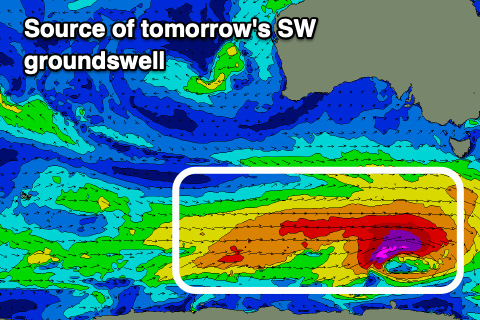
The fore-runners of a strong new SW groundswell are due to arrive this afternoon, with a peak in size due through tomorrow across the state. The source of this swell was a strong polar frontal progression that developed over the weekend, with a fetch of pre-frontal W/NW gales strengthening further to the severe-gale range, south-west of Tasmania last night.

The progression was a touch faster than ideal, to the east through our swell window, but with the strongest stages generated nicely in our south-western swell window, we should see a moderate to large groundswell peaking in the 4-6ft range on the Surf Coast magnets tomorrow, with 6ft to occasionally 8ft sets to the east.
Unfortunately the timing of a frontal system spawning off the progression is right on dawn tomorrow, bringing strong S/SW winds and poor conditions. The chance of lighter W/NW winds right on dawn is possible, but they won't last long.
Wednesday will be on the backside of the swell, though the easing trend looks to be drawn out thanks to a reinforcing mid-period S/SW swell generated by trailing W/SW winds behind the gale-force winds.
Winds will remain onshore but only moderate out of the S/SE with easing 4ft+ waves on the Surf Coast and 6ft sets to the east.
A small trough looks to swing winds back to the SW-S/SW on Thursday as the size drops further, with an outside chance of W/NW winds early on the Surf Coast. Lower your expectations if heading for a paddle.
Friday will become cleaner under a W/NW-W breeze, and a new pulse of mid-period S/SW swell is due to arrive through the afternoon, peaking Saturday. The source is mixed, with a small polar fetch of strong to near gale-force W/NW winds creating one component, with a closer fetch of weaker W/SW winds to the south-west of Tasmania on Wednesday evening creating the second component.

The Surf Coast looks to come in at a smaller 2ft to occasionally 3ft Friday morning, 4ft to the east ahead of the new mix of swells building more to 3ft and 4-5ft respectively into the afternoon.
Saturday should reveal a touch more size again thanks to a stronger frontal system developing on the tail of this activity to the south-west of Tasmania, producing surf more to 3-4ft and 5-6ft respectively.
Winds should be favourable on Saturday, with an overnight trough that will bring S/SW winds expected to clear to the east ahead of a cold front, allowing winds to swing back to the W/NW-W through the day. The front will clip the state on Sunday, bringing a SW change mid-morning along with a further increase in swell.
Continued strong polar and Southern Ocean frontal activity looks to setup a good week of moderate to large swell pulses into next week with winds out of the western quadrant. We'll have a closer look at this on Wednesday though.

