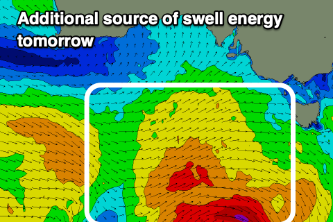
Fun run of swell with moderate sized swells and favourable winds
Victorian Surf Forecast by Craig Brokensha (issued Wednesday 19th April)
Best Days: Tomorrow Surf Coast, Friday morning Surf Coast, Saturday Surf Coast, Monday, Tuesday exposed beaches, Wednesday, Thursday Surf Coast
Features of the Forecast (tl;dr)
- Moderate sized, mid-period W/SW swell building Wed with moderate W/NW tending fresh SW winds early PM
- Peak in moderate sized W/SW and SW swells Thu with W/NW tending variable winds
- Slowly easing surf Fri with W/NW tending moderate SW-S/SW winds early PM
- Slowly easing surf Sat with light NW winds ahead of a late, shallow S/SW change
- New, inconsistent W/SW groundswell building Sun, peaking in the PM with early W/NW tending S/SW winds mid-late AM, S/SE into the PM
- Easing swell Mon with local offshore winds, N/NE into the PM
- Low point in swell Tue AM with gusty N/NE winds
- Inconsistent, moderate sized W/SW groundswell arriving later Tue, peaking Wed with strong N/NE tending weaker N/NW winds
- Easing surf Thu with strong NW tending W/NW winds
Recap
Good to great conditions across the beaches yesterday with a drop in swell back to 2ft on the Surf Coast and 3-4ft to the east. Conditions became wind affected into the afternoon as winds strengthened from the N/NW.
This morning we've got a low point in swell with favourable winds for the Surf Coast, coming in at 1-2ft, while the exposed beaches to the east are wind affected and to 3ft. Winds will strengthen from the SW early afternoon along with a moderate sized, building W/SW swell.

Stacked yesterday AM
This week and next (Apr 20 - 28)
We've got an active period of moderate sized surf from this afternoon through the weekend and into next week thanks to a constant progression of frontal systems under the country, mostly through our western swell window.

The first pulse of swell due this afternoon was generated by a strong mid-latitude front pushing up towards and then under Western Australia earlier this week.
This front has dipped east-southeast, generating a fetch of strong to near gale-force W/SW winds through our south-western swell window last night, while a secondary weaker front will produce strong west winds through today before weakening tomorrow.
What this all equates to is a peak in moderate sized W/SW-SW swell tomorrow, coming in at 3-4ft on the Surf Coast and 6ft+ to the east, easing slowly from a slightly smaller and less consistent size range on Friday.
Conditions will be great on the Surf Coast with W/NW tending variable winds tomorrow, clean again Friday morning with a W/NW offshore ahead of a shallow SW-S/SW change early afternoon.
Saturday looks to be the next low point in energy with slower, leftover 2ft to occasionally 3ft sets on the Surf Coast magnets, 4ft+ to the east and with NW winds holding most of the day ahead of a late afternoon, shallow S/SW breeze.
Into Sunday, a new pulse of inconsistent W/SW groundswell should fill in, possibly undersized early but fully in by mid-late morning. This will be generated by a frontal system tracking in, from under Western Australia, strengthening south of the country while dipping east-southeast. A fetch of fast tracking, gale to possibly severe-gale W/NW winds are due, with the swell due to be moderate in size and arriving from the W/SW initially but peaking into the afternoon from a SW direction.
EC has the system being a touch weaker, so I'll be cautious on size and review it on Friday but the Surf Coast should reach 3ft into the afternoon with 4-5ft+ sets to the east under a morning W/NW breeze, that will shift S/SW mid-late morning and S/SE into the afternoon.
Easing surf is then due on Monday with local offshore winds, favouring the exposed beaches which look to see N/NE-NE winds holding into the afternoon.
A temporary low point is expected early Tuesday with gusty N/NE winds, strengthening further into Wednesday ahead of an approaching frontal system.

Swell wise, a new pulse of W/SW groundswell is due into the afternoon on Tuesday, peaking Wednesday. This looks to be generated by another strengthening low to the south-west of Western Australia on the weekend, with the models agreeing on the scope and strength at this stage.
A good 3-4ft of swell is due to peak Wednesday morning on the Surf Coast, 6ft to the east and with those strong N/NE tending N/NW winds.
Following this there's plenty more activity on the cards with varying winds. More on this Friday.


Comments
Anyone else getting issues with the cape sorrell buoy data? I can't seem to view any updates since 8:30am Monday
Yep same here
Ship ran over it.
Cape du Couedic is also offline, so a BOM error.
Yep an abomination!!
This is a classic little run of mid sized swell for the surf coast. Love the mix of beachie and reef days. Finally a good run of swell / wind days to be proud of.
+1. Super super fun forecast