Small windows of clean conditions to work with
Victorian Surf Forecast by Craig Brokensha (issued Friday 24th February)
Best Days: Tomorrow ahead of the change, Sunday morning Surf Coast, possibly Thursday morning
Features of the Forecast (tl;dr)
- Small-moderate sized, inconsistent mid-period W/SW swell building tomorrow, peaking Sun AM
- Strong N/NE winds tomorrow, easing early PM ahead of a shallow SW change by mid-PM
- Mod-fresh W/NW winds Sun, shifting S/SW late AM
- Moderate sized, inconsistent SW groundswell building Mon, holding Tue, easing Wed
- Gusty S/SW winds Mon, mod-fresh S/SW Tue, strong S/SW Wed
- Easing swell Thu with possible variable winds in the AM
Recap
Great conditions yesterday but with no surf left in the tank, fading from 1-1.5ft across the exposed beaches to the east, better on the Surf Coast and to 2ft in the morning at exposed spots.
Today the swell has bottomed out as wind strengthen from the north ahead of a slow moving low in the Bight.

About as small as it gets
This weekend and next week (Feb 25 – Mar 3)
Looking at the weekend ahead, and the window of clean conditions across the beaches looks decent as the remnants of the weak low in the Bight pushes further east. It will weaken on approach tomorrow, resulting in a tricky day of winds.
Early, strong and gusty N/NE winds are due hold to the east at least until midday, possibly even early afternoon, with them easing right ahead of a shallow S/SW change.
This will be as an inconsistent, mid-period W/SW swell fills in, generated by a healthy low that formed in the Heard Island region at the start of the week.
The swell will be small to tiny and slow in the morning but we should see fun sets building through the late morning, early afternoon just ahead of the change. Later in the day the Surf Coast may see 2-3ft sets on the magnets, with 4-5ft sets to the east, but Sunday morning is a greater chance for this.
Winds are now looking better for early Sunday, with a moderate to fresh W/NW breeze due before shifting S/SW late morning. With the peak in mid-period swell it should be worth a surf, but expect a long wait for the best sets.

Unfortunately early to mid-next week look poor with a high expected to slide in behind Sunday's trough linked to the late morning change. Fresh and gusty S/SW winds are due on Monday, easing a touch Tuesday but still remaining onshore. Wednesday looks to see a polar front pushing up and across us, with a possible tiny window of early W'ly winds, but otherwise strong from the S/SW.
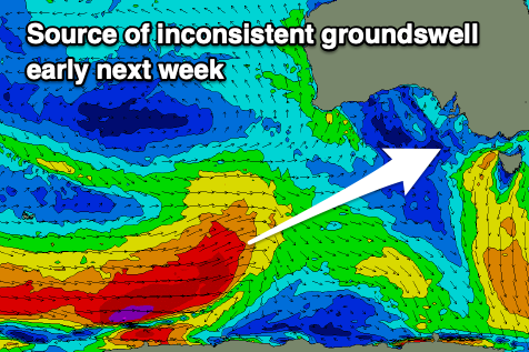
Swell wise, these onshore winds will spoil a fun sized mix of groundswell and mid-period energy that's due to build Monday, followed by reinforcing pulses Tuesday, easing Wednesday.
These swells have and are still being generated by an elongated frontal progression that's developed between the Heard Island region and south of Western Australia. An elongated fetch of gales is being produced, with a few slightly stronger bursts in the mix.
It'll be inconsistent but sets to 4ft are due to develop on the Surf Coast Monday afternoon, holding Tuesday and then easing from 3ft+ on Wednesday. To the east surf to 6ft is expected on the sets, easing from 4-5ft on Wednesday.
Into the end of the week winds are expected to ease, with possible variable offshores due on Thursday morning, but we'll confirm this Monday.
Longer term we've got some decent S/SW groundswell on the cards for next weekend but with what looks to be S'ly winds thanks to a persistent high sitting in the Bight. More on this Monday. Have a great weekend!


Comments
Max height .67m @ 2.3secs at PNP
GarrANT Mcnarma be waxing his rhino chaser for sure.
I’m here all day folks.
you forgot the degrees bone, 339 degrees
Lordy lordy that is a seriously grim forecast. Picked a good week to be out of the water. Gouged the arm on reef, have to keep it dry and clean. Nothing to be lost.
Agree, great day to bash a toe on a rock and let it heal.
Appreciate the support VJ.
My unco-ordination is there for you blackers :)
What's yours like?

Yeah ouch! Get well soon blackers, I see some stitches there.
Just a little kick for me, blooded area about a toenail in size, skin ripped away, 'tis but a scratch'.
The North side of "the Island" could be worth a paddle on the Long Board early next week.NewSW ground swell and SW winds work Okay over there.
What a completely depressing forecast other than a single morning. Swell in the water but with unruly onshore winds! Nowhere to hide!!