Persistent east winds with easing surf from tomorrow
Victorian Surf Forecast by Craig Brokensha (issued Friday 16th November)
Best Days: Selected beaches tomorrow morning and Sunday morning, keen surfers on the beaches Monday morning
Features of the Forecast (tl;dr)
- Moderate sized SW groundswell for later today, peaking tomorrow AM with light E/NE tending gusty S/SE winds
- Easing swell Sun with fresh, gusty E/SE winds (E'ly at period across PI), strengthening from the S/SE
- Poor mix of swells Mon with gusty E tending SE winds
- Small, weak surf with gusty E tending SE winds
- Small to tiny mix of swells Wed with E/NE tending SE winds
- Inconsistent, moderate sized W/SW groundswell for next Fri with gusty S/SE winds
Recap
The coast still offered plenty of size yesterday with a mix of S/SW swells though conditions remained poor with nowhere to really recommend for a surf thanks to strong southerly winds.
Today winds are easing across the state along with a drop in size. Conditions are improving further for beaches to the east offering surfable options for the keen. Later in the day we should see some new SW groundswell but gusty S/SE breezes are due.

On the improve this AM but still scrappy
This weekend and next week (Dec 17 - 23)
Looking at the weekend ahead and we've got a further improvement in conditions due tomorrow, thanks to the low in the Tasman Sea weakening slightly while pushing to the east, away from the Victorian region.
This will see winds shift E/NE tomorrow morning, creating cleanish, lumpy waves to the east, bumpy on the Surf Coast and best across the beaches. The issue is the incoming SW groundswell, with it due to be quite punchy in size, likely overpowering a few spots.

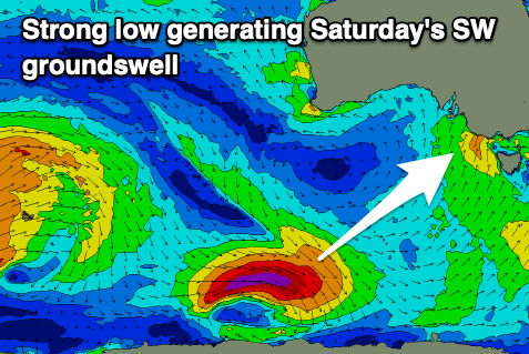
The morning high tide will help but we're expected to see 3-4ft sets on the Surf Coast magnets and 5-6ft waves to the east, easing into the afternoon. As mentioned through the week, this swell was generated by a strong, tight polar low that fired up to the south-southwest of Western Australia earlier in the week, with a good fetch of gale to severe-gale W'ly winds generated.
The models are showing a peak in size through the middle of the day tomorrow but this isn't expected, as they're combining some mid-period energy with the groundswell and over-representing the size.
Easing surf is expected through Sunday back from 2ft to possibly 3ft on the Surf Coast and the 4ft range to the east as winds start to strengthen from the E/SE. This will be linked to the high sitting to our west starting to push in, squeezing the low in the Tasman Sea.
Phillip Island may see more E'ly winds at times but Monday looks a better and more reliable chance fo this. The swell will be smaller and fading from the 2ft+ range on the exposed beaches, while the E/SE-SE winds will generate some poor quality SE windswell on the Surf Coast.
The slow movement on the high will see winds persisting from the east into Tuesday and Wednesday mornings (gusty SE afternoons). Swell wise there's unfortunately nothing significant with a small mid-period S/SW swell for later Sunday/Monday being hard to distinguish under the local SE windswell.

There's a tiny, long-range W/SW swell due mid-week but again it doesn't look to really get above 2ft on the exposed beaches to the east.
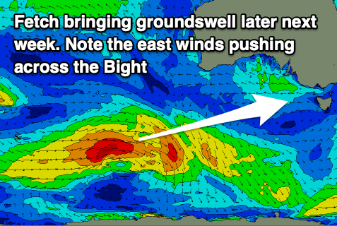
Later in the week some new, inconsistent W/SW groundswell is on the cards, generated by a distant but strong polar frontal progression east of the Heard Island region. This and a secondary pulse for the weekend unfortunately look to peak with S'ly winds as a trough pushes through Thursday evening, followed by a strong high. We'll have a closer look at this and what looks to be an increased in storm activity through the Southern Ocean on Monday. Have a great weekend!

