Poor end to the week, beachy options for the weekend
Victorian Surf Forecast by Craig Brokensha (issued Wednesday 7th November)
Best Days: Saturday morning exposed beaches, Sunday morning exposed beaches, Monday afternoon/evening protected spots, Tuesday protected spots, Wednesday morning protected spots
Features of the Forecast (tl;dr)
- Moderate + sized SW groundswell building this afternoon, easing tomorrow
- Moderate sized SW windswell tomorrow, easing Fri
- Strong SW tending S/SW winds tomorrow, strong S/SE-S early Fri, easing back to mod-fresh
- Small Sat with E/NE-E tending SE winds
- Inconsistent, small W/SW swell Sun with strengthening NE winds, shifting W/NW into the PM and SW late PM
- Moderate sized W/SW swell building Mon with gusty W/NW tending SW winds, back to the W/NW later
- Easing surf Tue with strong WNW-W winds
- Moderate sized + swell building Wed with W/NW tending SW winds, peaking Thu with S/SW winds
Recap
Monday's stormy increase in S'ly swell eased back overnight and dropped from 3ft+ on the Surf Coast and 3-4ft to the east yesterday as winds eased and swung offshore to the east, creating improving conditions through the morning ahead of sea breezes. The Surf Coast was poor early but also improved through the morning as onshore winds relaxed.
This morning we've got smaller, peaky leftovers to 1-2ft on the Surf Coast and 2ft+ to the east with offshore winds. A trough is now bringing an onshore change, while we should see a good pulse of new SW groundswell this afternoon but with strong SW winds.
This week and weekend (Dec 8 - 11)
This morning's trough and strengthening SW change will bring a poor end to the week wind wise, spoiling a good, moderate + sized SW groundswell that's due to fill in this afternoon and ease through the coming days.

Strong SW tending S/SW winds will create terrible conditions as the groundswell, which was generated by a strong low earlier this week, eases back from 4-5ft tomorrow and 6ft to possibly 8ft to the east.
There'll be some more consistent, localised windswell in the mix from the strong SW winds, disguising the underlying groundswell.
Both swells will ease into Friday as winds swing to the S/SE, strong early but easing back to moderate to fresh through the day.
The weekend holds more promised for a quality surf as winds shift to the east along with some small, background mid-period swell pulses.
Saturday looks smallest as we fall in between pulses, with the Surf Coast due to come in around 2ft, with 3ft sets to the east and a morning E/NE-E wind should favour exposed spots. The afternoon will become bumpy with sea breezes.

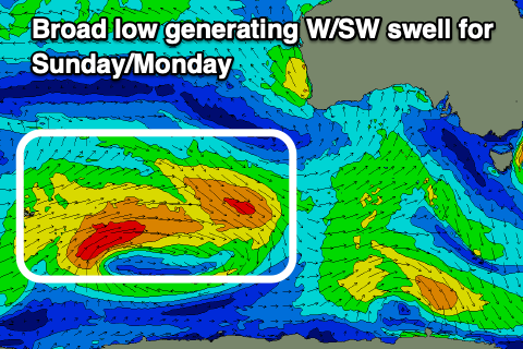
Into Sunday, the first pulse of mid-period W/SW swell should peak, generated by a good fetch of pre-frontal W/NW winds at the head of a broad low that's currently south-west of Western Australia.
The tail end of the low will generate strong W/SW winds and a secondary, reinforcing pulse of swell for later Sunday and Monday morning.
Both look inconsistent and small, coming in around 2ft on the Surf Coast magnets and 3-4ft to the east. Winds will strengthen from the NE, favouring the exposed beaches in the morning, though another trough will move through into the afternoon, swinging winds W/NW ahead of a late afternoon SW change.
Quickly, it's also worth noting there might be some small SE swell energy in the water Saturday and Sunday morning across selected locations, generated by a broad, strong Tasman Low.
Winds are expected to revert back to the W/NW on Monday, strengthening owing to the formation of a strong mid-latitude low directly west of us on Sunday.
The position of the low at this stage looks a little too far north for us to see any major size, but any shift further south will result in a much different swell outlook.
With the current forecast position we can expect a rapid jump in mid-period W/SW swell through Monday, building to 4ft on the Surf Coast and 6ft to the east. Winds look to swing SW for a period through the afternoon but then back W/NW late (we'll confirm this Friday).

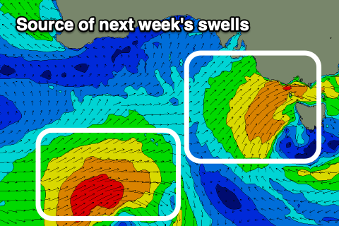
The swell is due to ease steadily through Tuesday under strong W/NW tending W winds as a secondary more favourably positioned low pushes up towards us.
Easing surf from 3-4ft is due on the Surf Coast and 5-6ft sets to the east.
This low is expected to bring a building mid-period swell Wednesday morning ahead of some better energy later in the day, peaking Thursday. Size wise a peak in the 4ft+ range on the Surf Coast and 6ft+ to the east is expected but with S/SW winds on Thursday as we fall under the influence of the backside of the low.
We'll have a closer look at this on Friday.

