Building swell energy with winds from the western quadrant
Victorian Surf Forecast by Craig Brokensha (issued Monday 21st November)
Best Days: Protected spots today, tomorrow and Wednesday morning, Thursday morning Surf Coast, Friday both coasts ahead of sea breezes, early Saturday on the beaches
Features of the Forecast (tl;dr)
- Mod-large, mid-period W/SW swell building this afternoon, peaking tomorrow with fresh-strong W/NW tending W winds tomorrow
- Large S/SW groundswell for Wed with mod-fresh W/NW tending SW winds late AM
- Easing S/SW swell Thu with moderate W/NW-NW tending S/SW winds late AM
- Smaller Fri AM with light NW tending N/NE winds ahead of SE sea breezes
- Small, mid-period SW swell for Fri PM, peaking Sat with strengthening N/NE tending N/NW winds ahead of a SW change mid-PM
- Easing surf Sun with SW winds
Recap
Friday's fun swell dropped back through Saturday with an inconsistent reinforcing pulse of SW swell coming in at 2ft+ on the Surf Coast, 4ft to the east along with some sneaky, peaky mid-period SE swell in the mix.
The beaches were the pick with some spots firing with offshore winds holding all day.
The swell bottomed out through yesterday as winds strengthened from the west ahead of a vigorous cold outbreak. This strong, cold change is bringing a building low-period W/SW swell through today with 3ft+ waves reported this morning (Surf Coast )and more on the way as winds shift W/SW-W. More on this below.
This week and weekend (Nov 22 - 27)
The current strong cold outbreak that's pushing in and across us from the west had origins on the polar shelf, to the south-west of Western Australia last week.
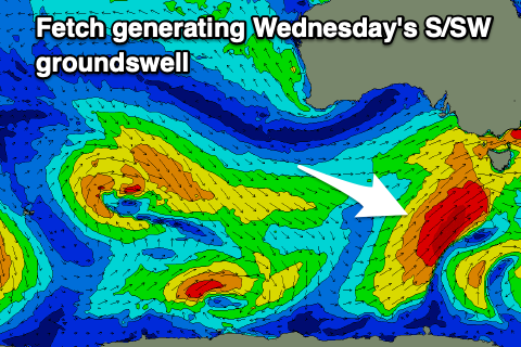
It's producing a fetch of strong W/SW winds, followed by trailing SW winds, leading to today's building mid-period W/SW energy which will tend more SW and peak temporarily ahead of a larger S/SW groundswell into Wednesday.
 This larger and stronger S/SW swell will be generated by a strengthening polar front being dragged up through our southern swell window this evening and tomorrow, generating an additional fetch of S/SW gales on top an active sea state.
While the models are showing a peak in size this evening through tomorrow, Wednesday will provide the most energy on the Surf Coast, with tomorrow due to come in at 4-5ft+ with 6-8ft sets to the east, while Wednesday pulse of S/SW groundswell should peak to 6ft on the Surf Coast and 8ft to the east.
Locally, winds will favour protected spots with a fresh to strong W/NW tending W wind tomorrow, and moderate to fresh W/NW tending SW winds later morning Wednesday.
Into Thursday, we'll see the S/SW swell easing and a W/NW-NW offshore will favour the Surf Coast. The size should drop from the 4ft range on the Surf Coast, 5-6ft to the east. Conditions will deteriorate into the afternoon with a S/SW breeze, while the beaches should start to improve into Friday as winds tend more N/NE during the morning and early afternoon ahead of sea breezes. An early light NW breeze will likely create lumpy conditions, so give it a few hours.
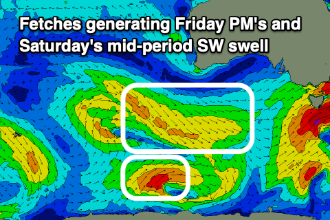
 More manageable surf is due Friday morning, back to 2ft to possibly 3ft (Surf Coast) and 4ft to the east. A small, mid-period SW swell is due into the afternoon, with a secondary pulse for Saturday, generated by a weak frontal system moving through the Southern Ocean, producing a fetch of strong W/NW winds, and polar SW winds just behind it.
Small 2ft+ waves are due on the Surf Coast Saturday, 4ft to the east along with strengthen N/NE tending N/NW winds ahead of a trough and strong SW change mid-afternoon.
Longer term we've got plenty more swell on the cards for next week as a mid-latitude frontal progression starts to strengthen and push across us early in the week, but we'll have a closer look at this on Wednesday.


Comments
If we're going to cop this farkin freezing weather late November, at least it's giving us swell and offshores. I nearly froze in the carpark this morning getting out of the wettie
How are we going vs historical average temps and rainfall for November? Feels really cold, the neighbours have the fireplace on in the day which is an important barometer.
It's exciting weather tbh. Christmas in July in November.
Will have a more in depth article, look up this week.
great stuff, thanks. I reckon there'd be more snow on the Alps Craig...
Have a read of this blog post I did here. Two Friday's ago..
https://www.ski.com.au/xf/threads/the-bc-chatter-thread.47700/page-477#p...
Agh, just saw your reply in the other thread haha. Yes more snow since then, so good!
Not just totals but frequency. When was the last time we went more than a couple of days without rain?
Tell me about it. The garden is making a subterranean lake above the clay layer, and large worms are coming to the surface.
How about the futile attempt to spray some weed killer... the stuff says you need to spray it when there isn't rain forecast for 72 hours. Fat chance of getting that!