Improving surf late week, winter-like outlook next week
Victorian Surf Forecast by Craig Brokensha (issued Wednesday 16th November)
Best Days: Friday morning on the beaches, Saturday on the beaches, Monday onwards Surf Coast
Features of the Forecast (tl;dr)
- Easing S/SW swell tomorrow with moderate S/SW tending S winds
- Small-mod sized SW groundswell arriving tomorrow PM, holding Fri AM with E/NE tending fresh S/SE-SE winds
- Reinforcing SW swell for Sat AM, easing with strengthening NE tending N/NE winds
- Small Sun with strong W/NW winds
- Mod-large SW swell building Mon with strong W/NW tending W/SW winds
- Large S/SW swell for Tue with strong W/NW-W winds
- Easing S/SW swell Wed with moderate sized pulses of reinforcing swell for the rest of the week with winds from the W-NW
Recap
A stormy mix of solid windswell, and mid-period SW and S/SW swells pulsed in size yesterday along with strong SW winds, leaving limited options for a clean wave. Protected spots on the Surf Coast were OK, cleaner this morning but still lumpy and raw along with a drop in energy. Winds will shift SW during the morning again, creating deteriorating conditions.
This week and next (Nov 17 - 25)
The slow moving low responsible for the cold weather, onshore winds and S/SW swell energy will clear off further to the east tomorrow, but winds will remain onshore out of the S/SW, moderate in strength, shifting S'ly into the afternoon.
 Friday finally looks cleaner across the beaches as winds shift E/NE through the morning ahead of SE tending S/SE sea breezes.
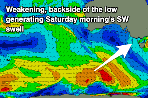
Looking at the swell, and we should see the current S/SW energy easing into tomorrow morning, ahead of an inconsistent pulse of SW groundswell tomorrow afternoon and Friday morning, followed by a reinforcing pulse for Saturday morning.
As touched on in Monday's notes, a strong but slightly poorly structured low (for swell generation across our state) has generated a fetch of pre-frontal NW gales, producing tomorrow afternoon's pulse of SW groundswell, while a trailing fetch of strong to near gale-force SW winds on the back will generate the slightly weaker reinforcing swell for Saturday morning.
Size wise, tomorrow afternoon's should offer 3ft waves on the Surf Coast and 4-5ft sets to the east, holding Friday before easing a little in consistency through the afternoon.
 Saturday morning will be less consistent but sets to 3ft are still due on the Surf Coast magnets, 4ft to occasionally 5ft to the east, easing through the day. A strengthening NE tending N/NE breeze will favour the beaches, best in the morning.
Sunday still looks to be a lay day as winds shift to the W/NW and strengthen as another strong cold outbreak develops to our south-west,
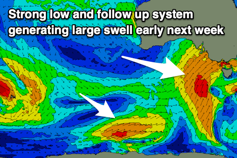
Now, this progression looks stronger and more prolonged than the current event, generating large surf through early next week along with plenty of wind and more snowfalls.
The structure and timing of each pulse and the local winds will move around a bit, but we're looking at a slow moving, deepening low forming west of us on the weekend, pushing east across us into Monday, bringing strong NW tending W/SW winds and a building SW swell, large and out of the S/SW Tuesday.
 It looks like the Surf Coast will peak in the 6ft range with 8ft+ surf to the east under strong W/NW-W winds.
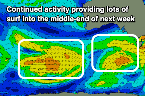
The swell will ease through the middle of the week but likely remain moderate in size along with favourable NW-W winds owing to an active westerly storm track through the rest of the week. We'll have a closer look at all this on Friday though.


Comments
The weather charts for Saturday through to mid-next week are amazing. I've never seen a period like this before where the highs out west keep running into lows below Tassie, dragging up cold winds and rain from the Antarctic every couple of days. Isobars packed tighter than a gnat's arse. Been rinse and repeat since June / July with no change right into early summer.
And what's that out west? The next pulse of rain from the Indian Ocean! BoM's (take that you branding tools!) climate driver update next Tuesday gonna be interesting.
BOM are like stock market experts at the moment; good at explaining retrospectively, unconvincing at forecasting.
haha very well said
chocolatey goodness flowing into the ocean from the creeks, true brown water experience...
Must be untouched by human hands.
For the old school...