Options galore this period
Victorian Surf Forecast by Craig Brokensha (issued Friday 26th August)
Best Days: This morning, exposed beaches tomorrow and Sunday, Monday select locations working the winds, Wednesday Surf Coast, Thursday, Friday
Features of the Forecast (tl;dr)
- Mid-period SW swell for Sat AM, easing slightly later and further Sun
- N/NE tending E winds (mid-afternoon) Sat, strengthening N/NE winds Sun, easing late
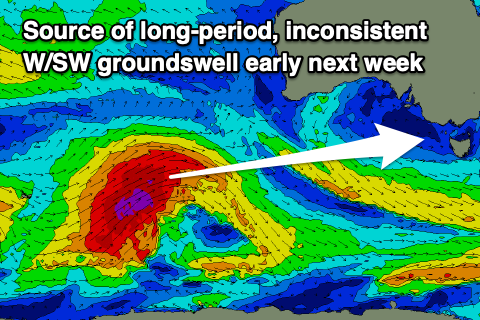
- Inconsistent, long-period W/SW groundswell arriving Mon PM, biggest later with strong N/NE winds, easing and tending variable mid-late PM ahead of a strong evening SW change
- Easing groundswell Tue with strong SW winds, easing during the day
- NW tending W winds Wed with a moderate sized, inconsistent SW swell for the mid-late PM
- Steady wave heights Thu with light W/NW tending variable winds
- N/NW-N winds Fri and a moderate sized SW swell, possibly kicking a bit more in size later
Recap
Wednesday's pumping surf became more wind affected yesterday though decent through the morning on the Surf Coast with sets to 3-5ft, bumpy and average to the east.
Conditions deteriorated into the afternoon as winds shifted more south and freshened as a front clipped us.
This morning we've got variable winds and cleaner conditions across all locations, lined up but a little too big for the beaches to the east and to 4-6ft, with clean 4ft sets on the Surf Coast magnets.
Winds will shift S''ly around midday and become moderate out of the S/SE through the afternoon, creating bumpy conditions.
This weekend and next week (Aug 27 – Sep 2)
It's been a great week of surf across the Surf Coast reefs, and the beaches will get their time in the sun this weekend as a high moves in from the west, shifting winds more around to the north-east.
A moderate N/NE offshore is due tomorrow, tending more E'ly mid-afternoon though hopefully not swinging proper SE. Either way there'll be plenty of time for two surfs before conditions deteriorate.
Swell wise, we've got a reinforcing mid-period SW swell due to arrive later this afternoon, followed by a smaller pulse tomorrow and these should maintain less consistent 3ft sets on the Surf Coast magnets, 4ft to occasionally 5ft to the east.
Sunday will see a noticeable drop in size, with easing sets from generally 2ft+ to the west and 3-4ft to the east. Strengthening N/NE winds will favour the exposed beaches again, easing a touch into the late afternoon.
 Monday will become windy with strong N/NE winds, easing considerably mid-afternoon ahead of an evening, strong SW change.
Size wise, the morning will be small and slow, a low point in energy, but our inconsistent, new long-period W/SW groundswell should start to show late morning but more so into the afternoon.
The strong polar low linked to this swell has been generating a great fetch of severe-gale to storm-force W/SW winds in our far swell window and is now tracking north-east towards Western Australia with strength. The low will weaken this evening and through tomorrow, with the moderate sized W/SW groundswell travelling towards us on the weekend.
It'll be inconsistent but punchy when the sets push in with building surf to 3-4ft by dark on the Surf Coast and 6ft to the east with those easing winds ahead of the late/evening change.
Tuesday looks poor with easing, gusty SW winds and similar sized surf to late Monday, easing through the day.
 Not to worry as we've got some fun, moderate sized and more consistent swell with favourable winds due from later Wednesday through the end of the week.
The source of the swell will be polar frontal activity moving in from south-west of Western Australia during the weekend and early next week, with an initial kick in size later Wednesday, peaking Thursday morning followed by a secondary pulse Friday afternoon.
Size wise, Wednesday morning looks 2-3ft on the Surf Coast and 4-5ft to the east with a NW tending W offshore, with the late afternoon kicking to 3ft to possibly 4ft on the Surf Coast and 6ft on the sets to the east.
Thursday should see inconsistent 3-4ft waves on the Surf Coast and 5-6ft waves to the east with W/NW tending variable winds, N/NW-N on Friday along with similar sized sets.
Friday afternoon's pulse may kick a touch stronger in size but we'll have a review of this Monday. Into the weekend a cold front looks to bring an onshore change, but again check back here Monday. All in all it's a decent looking forecast. Have a great weekend!


Comments
What model does willyweather use for winds?
Also,
Good Conditions - tick
Good Waves - ?
We pray.
BOMs ACCESS model
The swell this arvo was non stop. Why can’t you get that when it’s 3ft?
The winter we know and love
From all accounts a great Saturday on the Surf Coast and arvo to the east, fun to the east yesterday but with freezing water. How everyone go?
Probably call it the best week of surf we've had all winter. Remember though that's coming off the lowest of low bases in the history of surfing since man first dipped toe in water.
Haha yeah, how good! Body must be feeling it.
Couple of days rest then I hope you'll tell me we're back on for mid-late this week Craigos
Saturday was all time. Sunday a little smaller than expected but still fun.
I've found the water to be manageable, been going with out boots and gloves, and only brining the hood out for ear protection when windy.
How quickly do we forget about the bad times when the swell finally returns!!
.