Large, stormy surf for the weekend
Victorian Surf Forecast by Craig Brokensha (issued Friday June 10th)
Best Days: Tomorrow morning Surf Coast, protected spots for the experienced Sunday, keen surfers early Monday Surf Coast, Tuesday Surf Coast
Features of the Forecast (tl;dr)
- Secondary pulse of slightly stronger S/SW swell later Fri, easing Sat AM
- Large S/SW groundswell filling in Sun
- Fresh W/NW tending stronger W/SW winds midday Sat
- Strong SW winds Sun (W/SW early Surf Coast)
- Mod-fresh SW winds, abating Mon (likely W'ly for a period on the Surf Coast in the AM)
- Strengthening N-N.NW winds Tue with fading swell
- Inconsistent small S/SW groundswell Wed with strong N tending NW winds
- Weak mid-period W swell Wed
Recap
Moderate levels of S/SW swell across the state, cleanest though still lumpy on the Surf Coast and in the 4ft range on the sets. Locations to the east have been poor and a mess. We should see a further increase in S/SW swell during this afternoon but with a strong SW breeze.
This weekend and next week (June 11 - 17)
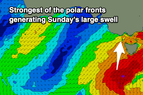
Tomorrow morning is the pick of the weekend regarding local conditions as we see winds tip back to the W/NW again ahead of the strongest polar frontal system projecting north around a large, slow moving Southern Ocean gyre.
Ahead of this today though we’re seeing a good system projecting north, with a moderate + sized mid-period S/SW swell due to fill in later today, peaking overnight and easing tomorrow.
 The swell will have a touch more period and strength, with the Surf Coast due to ease from the 4ft+ (5ft sets magnets) range with 6ft sets to the east. The W/NW offshore will last until later morning, then shifting W/SW thereafter, not entirely bad.
Come Sunday, poor and strong W/SW tending SW winds are due with the largest pulse of S/SW groundswell filling in. This will be generated by the strongest and final front within our swell window with a fetch of gale to near severe-gale S/SW winds being projected up past Tasmania tomorrow.
This should produce large, stormy 6-8ft surf on the Surf Coast during the day (8ft Bells and Winki), 8-10ft to the east but unfortunately conditions will be poor with the local winds.
Moving into Monday the swell will start to ease and winds will abate as the gyre moves slowly east. Fresh SW winds are due across most locations, backing off to moderate through the afternoon but there might be a short-lived period of W’ly winds around Torquay early.
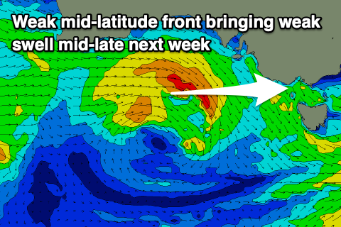
 Size wise the Surf Coast should ease back from 4-5ft on the sets with 6ft surf to the east, smaller Tuesday as winds shift to the N-N/NW and strengthen. This will be ahead of a mid-latitude frontal system moving in from the west but the swell will be small and fading back from 2ft+ on the Surf Coast and 3ft to the east.
A flukey S/SW groundswell may be seen on Wednesday from a small strong polar front firing up late in our swell window but strong N tending NW winds ahead of the nearing mid-latitude low will bring poor tricky conditions. Swell wise it only looks to be 2ft+ on the Surf Coast and 3-4ft to the east.
Otherwise the mid-latitude front doesn’t look to generate too much in the way of swell with it riding too high through the Bight. Some weak W’ly swell may be seen through Wednesday afternoon/Thursday but we’ll have a closer look at this Monday. Have a great weekend!


Comments
Anyone hear what happened at Urbnsurf today? Heard guy in 40’s was critically injured, and pool closed.
https://www.news.com.au/national/victoria/news/man-rushed-to-hospital-in...
Channel 7 reporting that he hit his head on the concrete, got knocked out and had a heart attack. Hope he pulls through okay.
Fark that's horrible.
Yeah hope he’s okay.
Jeepers.
:-0
I could see how that could happen. Either you hit the pool floor or the side wall. It was one of the reasons I did not go back there .
I prefer to stick with the ocean.
Inside story is a medical issue while paddling. But yet to be confirmed.