Fun options on the beaches for the coming days
Victorian Surf Forecast by Craig Brokensha (issued Monday 29th November)
Best Days: Today, beaches tomorrow until early afternoon, beaches Wednesday morning, beaches early Thursday for the keen, beaches next Monday morning
Features of the Forecast (tl;dr)
- New, mid-period W/SW swell for this afternoon, holding tomorrow with NE tending E/SE-SE winds
- Easing swell Wed with local offshore winds ahead of a weak S'ly change in the afternoon
- Smaller Thu with light, local offshore winds ahead of sea breezes
- Inconsistent W/SW swell building Fri with strong SW tending S/SW winds (possibly W'ly for a very short period early on the Surf Coast)
- Peak in W/SW swell Sat with fresh S'ly winds, easing Sun with SE tending S/SE winds
- Smaller Mon with a NE offshore
Recap
A poor weekend of surf with gusty onshore winds and a weak mix of swells Saturday from the SE and SW, smaller yesterday with a slight improvement in winds for selected spots east of Melbourne.
Today conditions have improved further to the east of Melbourne with offshore winds and fun 3ft sets for the patient, bumpy and to 2ft on the Surf Coast. A new, mid-period swell should build through the morning and become stronger this afternoon but conditions will be bumpy with a S/SE sea breeze.

Clean lines this AM
This week and weekend (Nov 30 – Dec 5)
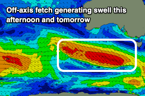
Our expected pulse of mid-period swell for tomorrow and Wednesday has been brought forward a little with the frontal progression linked to it racing in a little quicker than expected over the weekend.
A great, elongated fetch of off axis W/NW gales is responsible for the swell and while not ideally aimed, we should see a fair bit of energy spreading up radially into us.
 The swell should build this afternoon and reach 2ft+ on the Surf Coast and 3-5ft to the east, holding a similar size through tomorrow. Wednesday now looks smaller with the swell fading from 2ft and 3-4ft respectively, dropping further on Thursday.
Locally winds look great with a NE offshore tomorrow morning, possibly holding until mid-afternoon before shifting E/SE-SE later.
Wednesday will then see local offshore winds (N/NE on the Mornington Peninsula and N/NW on the Surf Coast), tending variable ahead of a weak trough and weak S'ly change mid-afternoon.
Thursday should be clean again with light local offshore winds, giving int afternoon sea breezes but the swell will be small and weak, best across the exposed beaches.
Into the evening a stronger trough and change will move through, bringing strong SW winds Friday (shifting more S/SW in direction through the day) that look to persist into Saturday.
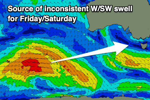
This will be as a new, mid-period W/SW swell fills in, generated by a broad, slow moving but distant polar low that's formed around the Heard Island region.
 Currently this low is generating a great fetch of W/SW gales but will weaken as it moves east over the coming days. A small intensification on the backside of the weakening progression during the middle of this week should produce an additional, more consistent pulse of W/SW swell for later Friday and Saturday morning.
So looking at the trend, a slow, inconsistent increase in size is due through Friday, building to 3ft to occasionally 4ft on the Surf Coast magnets through the afternoon and 5-6ft to the east. Saturday should be a more consistent 3-4ft and 6ft respectively though as touched on above winds will be poor. There's an outside chance of a very short-lived W/NW'ly dawn Friday but Saturday will see fresh S'ly winds.
Winds look to linger from the SE Sunday as the swell eases, while cleaner conditions are due on the beaches into early next week.
We've got a continuation of healthy polar frontal activity through the end of the week and weekend, generating some good swell for mid-late next week but a new ridge of high pressure looks to move in Tuesday bringing a return to S'ly winds, but more on this in the coming updates.


Comments
Get down to Kerferd Rd for some bombs!
You've obviously never surfed Kerferd Rd if you think this forecast means good waves there
Hoping that SE on Sunday can turn more east!
Hasn’t been a good weekly cycle for the weekend warriors