Poor weekend, much better next week
Victorian Surf Forecast by Craig Brokensha (issued Friday 26th November)
Best Days: Monday morning, Tuesday, Wednesday, Thursday morning
Features of the Forecast (tl;dr)
- Easing mix of SE windswell and background SW swell tomorrow with strong SE winds (possibly lighter E/SE early)
- Easing mix of small swells with mod-fresh E/SE tending SE winds
- Small, building mid-period SW swell Mon with E/NE-NE tending S/SE winds
- Better mid-period W/SW swells for Tue/Wed with N/NE tending NE winds
- Easing surf Thu with N/NE tending SW winds
Recap
Conditions weren't too bad all things considered yesterday morning with a mix of swells to 2-3ft on the Surf Coast and 4ft to the east with workable onshore breezes. Conditions deteriorated into the afternoon though as winds strengthened and this morning we've got poor surf all around with a moderate sized windswell. There's nowhere to recommend as winds shift south-east and strengthen.
This weekend and next week (Nov 28 – Dec 3)
Currently a trough that moved through Wednesday afternoon is now strengthening into a low off the southern NSW coast and this will see SE winds dominate Bass Strait through today and the weekend, strong before abating a little on Sunday as the low starts moving off towards New Zealand.
We'll see moderate levels of SE windswell and some easing W/SW groundswell tomorrow but options for a clean, quality wave will be limited. We may see winds tend E/SE for a little period early favouring some spots over others.
The Surf Coast looks to ease from the 3ft range with 3-4ft sets to the east, smaller Sunday with fresh E/SE tending SE winds. Again the morning looks to offer some OK options out of the wind for the keen but swell wise it'll be small.
Moving into next week conditions will improve as an inland trough moves in from the west, and the low clears further to the east allowing winds to tip more E/NE-NE.
A small pulse of new mid-period SW swell is due to fill in through the day Monday, generated by weak frontal activity south of the country today.
No major size is due with sets building to 3-4ft on the Mornington Peninsula, 2ft on the Surf Coast. Surf before lunch as S/SE sea breezes are due into the afternoon.
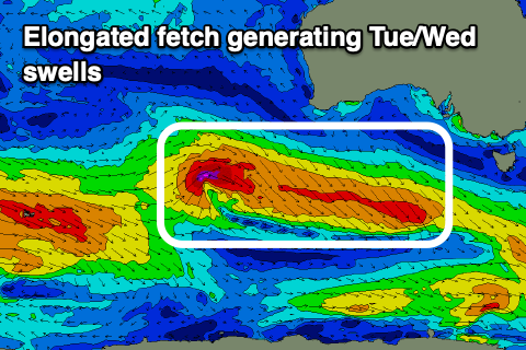
Our better pulse of swell for Tuesday is on track but it looks a little weaker now with the pre-frontal fetch of W/NW winds moving in from the west being more drawn out, faster moving and not quite as strong. This will be better for the beaches to the east though, with it not overpowering them as much.
We should see a fun kick in size to 3-5ft on the Mornington Peninsula with 2ft+ sets on the Surf Coast Tuesday with a light to moderate N/NE offshore wind that looks to hold from the NE into the afternoon, creating great conditions all day.
Wednesday looks great as well with persistent N/NE offshore winds and a reinforcing pulse of similar sized swell, generated by trailing W/SW winds. This looks to maintain 3-5ft sets to the east and 2ft+ waves on the Surf Coast, easing later in the day and down Thursday with N/NE winds again likely in the morning ahead of a trough and change through the afternoon.
 The trough will spawn off a broad, slow moving polar frontal progression that will begin its life around the Heard Island region this weekend, moving slowly east through early to mid-next week.
This will see a moderate sized, prolonged mid-period W/SW swell generated, arriving later Thursday but filling in further Friday with a peak on Saturday. Unfortunately winds at this stage look S/SE in the wake of the trough but we'll confirm this next week.
Size wise the Surf Coast looks to come in at 3-4ft during the peak of the swell with 6ft surf to the east but more on this Monday. Have a great weekend!

