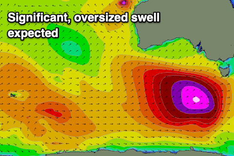
Significant swell inbound
Victorian Surf Forecast by Craig Brokensha (issued Wednesday 7th April)
Best Days: Thursday, Saturday morning Surf Coast, selected spots experienced surfers Sunday and early Monday, Tuesday
Features of the Forecast (tl;dr)
- Small SW swell with local offshore tending variable winds tomorrow
- Change Fri with a weak, building mid-period SW swell
- Better Sat with a peak in mid-period energy and morning W/NW winds
- Oversized SW groundswell for Sun with strong SW winds, easing Mon with fresh but abating S/SW winds
- Cleanest Tue with fresh N winds but on the way out
Recap
The swell was still solid across the state yesterday, easing from the 4ft range on the Surf Coast, 6ft to the east and with lighter onshore breezes, creating workable waves across selected spots.
This morning the swell has backed off a bit further with fun options on the Surf Coast beaches to 3ft, 4-6ft to the east but on the decline. Winds should remain light for the beaches until early afternoon so surf before then.
This week and next (Apr 8 - 16)
The swell from the start of the week will continue to drop in size tomorrow, but we'll continue to see fun 2ft sets on the Surf Coast tomorrow, with 3-4ft waves to the east.
Conditions will be cleaner across most spots with local, morning offshores (N/NW Surf Coast and N/NE Mornington Peninsula) tending variable into the afternoon.
Friday will be generally poor as a cold front brings a SW change (possibly W'ly for a period on the Surf Coast) but with no decent size. We'll be looking at a continuation of 2ft surf when cleanest, building into the afternoon briefly to 2-3ft but with those onshore winds. The Mornington Peninsula will be bigger but a mess.
Winds will swing back to the W/NW on Saturday morning ahead of our strong cold outbreak and 'bombing' low with the swell coming in at a better 3ft on the Surf Coast, 4-5ft to the east.
 Of greater importance is the swell from the 'bombing' low, with it still on track to drop over 24hPa of central pressure within a 24 hour period from this afternoon through tomorrow.
This will occur on the polar shelf, south-west of Western Australia, with a great fetch of storm-hurricane force W/SW winds expected to be projected east-northeast and then north-east up towards Tasmania while slowly weakening.
The slow movement and projection will result in a captured fetch scenario and greater than normal wave growth, resulting in an oversized, long-period SW groundswell event for Sunday.
The Surf Coast will come in at a large, consistent 8-10ft across the swell magnets through the day (possibly a touch undersized early), with 12ft surf to the east but with strong SW winds as the swell generating system impacts the state.
 We'll see the swell easing from the S/SW on Monday and still large, but with fresh S/SW winds, abating and becoming moderate through the day. Easing surf from the 5-6ft range and 6-8ft respectively.
Tuesday looks much better as a trough/mid-latitude low combo push in from the west, bringing fresh N'ly winds as the swell drops quickly in size and power from 3ft on the Surf Coast and 3-5ft to the east.
Longer term, the mid-latitude/trough combo pushing in won't bring much in the way of swell but we should see smaller, mid-period pulses with possibly favourable morning winds for the Surf Coast. More on this in the next update though.


Comments
Sunday along the GOR.... find ur fav point and enjoy
Provided you enjoy howling onshore winds and victory at sea conditions.
Wonder what the record crowd number at Lorne is?
We’ll sure as hell find out this Sunday
Is Lorne even a surfable wave on a short board
Not really...