Slow week before heating up into the weekend
Victorian Surf Forecast by Craig Brokensha (issued Monday 29th March)
Best Days: Exposed beaches Thursday and Friday mornings, Sunday morning, Monday morning Surf Coast, exposed beaches Wednesday week
Features of the Forecast (tl;dr)
- Small, inconsistent background swells this week with improving winds for the beaches later
- Building SW swell Sunday with easing morning SW winds, strengthening from the S/SW into the afternoon
- SW swell easing slowly Mon with a W/NW morning breeze, smaller Tue with S/SE winds, cleaner on the beaches Wed
Recap
Nothing special with a small mix of swells, cleanest on the Surf Coast and wind affected to the east.
This morning the swell is poor with an onshore wind and small, leftover swell.
This week and next (Mar 30 – Apr 9)
The coming days aren't overly special at all with background levels of swell stopping the coast from going flat, but not likely to provide much over 1-2ft on the Surf Coast and 3ft or so to the east.
Conditions tomorrow morning will be clean on the Surf Coast with a light W/NW breeze, giving into afternoon sea breezes, similar Wednesday but this looks to be when the swell reaches its lowest point.
The beaches will become cleaner late week with with a N'ly offshore on Thursday morning, N/NE Friday morning but with no major change to the sizes outlined above. Hit the exposed beaches for the best waves this week on Thursday and Friday mornings.
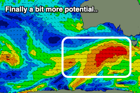
Now, as touched on the last few updates, we'll finally see a bit more activity from the weekend, that being Sunday into next week as a good, polar frontal progression pushes slowly east into our swell window, strengthening on approach through the weekend.
 An initial relatively weak cold front will generate an elongated fetch of pre-frontal W/NW winds, energising the Southern Ocean for a stronger, better aligned front, projecting a fetch of strong to gale-force W/SW winds through our south-western swell window Friday evening through Saturday.
This should produce a moderate sized SW swell that'll build Sunday, peaking later in the day, then easing slowly Monday. The easing trend will be slowed by weaker, trailing W/SW winds through our swell window, but the power will drop with a drop in period.
Looking at the size and the Surf Coast should build from 2-3ft to 4ft on the sets into the afternoon, 4-5ft to the east, reaching 6ft+ into the afternoon. Winds look dicey with a change on Saturday associated with the swell generating front lingering into the morning, SW but easing ahead of fresh S/SW sea breezes, back to the W/NW on Monday morning for a short period as the swell starts to ease.
A high will move in Tuesday bringing S/SE winds as the swell continues to drop, cleaner and fun on the beaches Wednesday.
Longer term the outlook is a little mixed with activity continuing to brew south-west of Western Australia but how this will transpire for us is up in the air. More on this in the coming updates.


Comments
I don't think the surfcoast has had a day of 3-4 foot nw wind since since October. And that last swell was inco
End of Feb.. https://www.swellnet.com/reports/forecaster-notes/victoria/2021/02/26/good-weekend-ahead 4-5ft+ clean groundswell.
Yep I remember that day well (and I say day, as we only really got one good day out of it). Anyone who owned anything that remotely resembled a board was in the water up and down the coast.
Really need a prolonged run now of good swell and winds to satisfy the wave hunger. Amazingly looks like we could get to mid-Autumn and it still won't happen.
From memory that swell was a bit wonky and the change came through by 12pm..
Worst Surfing Year of My Life. 60+ Years.
dr -surf. is not happy jan;)
Winds haven't been great down here but size is good. Normally too big this time of year but getting a paddle on average 3 times a week. Water is still toasty for here as well.