Workable weekend, very slight improvement next week
Victorian Surf Forecast by Craig Brokensha (issued Friday 5th March)
Best Days: Keen surfers on PI and the peninsula from mid-late morning tomorrow, exposed beaches Sunday, Surf Coast dawn Tuesday
Features of the Forecast (tl;dr)
- Moderate sized S/SW swell tomorrow with winds becoming light out of the S east of Melbourne through the morning, cleanest Sun with a N/NE breeze and small, fading swell
- Good new SW groundswell Tue with generally SW tending S/SW winds (light out of the W early on the Surf Coast)
- Easing swell with S/SE winds Wed, fresher S/SW Thu
Recap
Clean, small, weak waves in protected spots on the Surf Coast yesterday morning, bumpy and average across all other breaks, deteriorating through the day.
Today we've got stronger onshore winds and a kick in new swell but the quality is still lacking.
This weekend and next week (Mar 6 - 12)
The kick in swell today is from a strengthening polar front that developed south-west of us, now pushing across Tasmania under the influence of the strong node of the Long Wave Trough sitting across the Tasman Sea.
Today is mostly lower period energy but we'll see the swell strengthen in period through the afternoon, ahead of the strongest increase tomorrow.
Seeing today's jump in size, there's no expectation that tomorrow will be any bigger, and I'm still expected 3-4ft surf on the Surf Coast, continuing around 4-5ft to the east (smaller PI) owing to the southerly direction, then easing Sunday from 2ft+ and 3ft+ respectively.
Winds tomorrow still look average, but we'll see lighter onshore breezes the further east of Melbourne you go.
Strong onshore S'ly winds are due up until just before dawn, easing and tending light and possibly variable across Phillip Island mid-late morning, light S across the Mornington Peninsula, though still moderate on the Surf Coast. With this surfing from mid-late morning will be the go to allow the surf to clean up a bit.
Sunday is still the pick for clean conditions with a N/NE offshore, giving into a S/SW change mid-late afternoon as a trough moves through.
 Monday is still a lay day with a low point in swell and lingering light onshore winds in the wake of Sunday's change, strengthening through the day out of the S'th as a high moves in from the west.
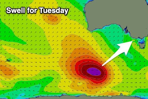
Our new SW groundswell for Tuesday is on track and there's no real change to the low generating the swell, but there's a very slight improvement in the wind outlook.
The low is currently south-west of Western Australia, generating a healthy fetch of severe-gale W/SW winds, but will dip south-east today while maintaining its strength. It should weaken slowly tomorrow evening before pushing east and breaking down south-west of Tasmania.
The swell will be a little inconsistent but should provide surf in the 4ft range across the Surf Coast (possible odd bigger one), 6ft+ to the east but with moderate SW tending fresher S/SW winds. The Surf Coast could now see a period of lighter, dawn W'ly winds, but there'll likely be a touch of lumpiness and wonk to conditions. Check back Monday for the final word on this.
Moderate S/SE winds are due Wednesday as the swell eases, back to the S/SW on Thursday as a low forms off the Gippsland coast, preventing the high to our west moving in any further.
Longer term we may see winds swing back offshore next Saturday out of the N/NE as the low clears to the east along with a new, mid-period SW swell, but we'll have a closer look at this on Monday. Have a great weekend!


Comments
Nice value add there Craig with the different wind foreys for tomorrow. Cheers.
Glad to know that Gary's not the only one here who loves having a few close range foreys come at him from different directions, Bnkref
Too close range and you will be cockeyed. But think of the foresight you will have.
Sperm whale washed up Forrest caves on the island.