Poor until next week
Victorian Surf Forecast by Craig Brokensha (issued Wednesday 10th)
Best Days: Tuesday, Wednesday and Thursday mornings next week across exposed beaches
Features of the Forecast (tl;dr)
- Weak W'ly swell building Fri PM with W/NW tending S/SW winds, easing Sat with morning W/NW winds
- Better though inconsistent SW groundswell building Sun PM with light to moderate S/SE winds, increasing, easing Mon with moderate S/SE winds, strengtheing from the SE, dropping further Tue with morning E/NE winds
- Fun, mid-period SW swell Wed with morning E/NE winds, easing Thu with morning N/NE winds
Recap
A bit of swell left across both coasts yesterday morning though onshore winds created generally poor conditions on the Surf Coast, a bit cleaner to the east and workable for the keen. Phillip Island was the pick with clean waves on the beaches.
Today we've got a mix of smaller, easing SW swell energy and localised SE windswell with cleaner conditions on the beaches but weaker, easing 2-3ft sets, 2ft or so on the Surf Coast.
This week and next (Feb 11 - 19)
Looking at tomorrow and while conditions will be clean on the exposed beaches with a fresh, strengthening NE breeze, size wise there'll be nothing left. A tiny, peaky mix of leftover SW and SE swell are due, mostly tiny if not for the rare 1-2ft'er across both regions for the patient. Come the afternoon the surf will likely be close to flat.
Friday will start tiny, and the W'ly swell for the afternoon still looks weak and average. The source of this swell is a weakening mid-latitude low pushing east over the coming days, but generating a very weak fetch of W'ly winds through our swell window.
Size wise, with the west component and low period, the Surf Coast isn't expected to reach 2ft by dark Friday, with Saturday likely seeing a touch more size, though only in that 2ft range. Sets to the east look to be a weak 3-4ft.
 Morning W/NW winds will create clean conditions Friday morning, shifting S/SW into the mid-late afternoon. Saturday should see a morning W/NW breeze, shifting S/SW again late morning.
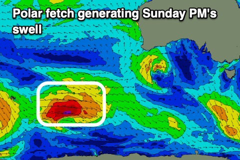
Our slightly stronger SW groundswell for Sunday is on track, with it due to build into the afternoon, generated by a stronger fetch of W/SW winds from a polar front forming east of Heard Island today. This will be in our far-medium range swell window, with the swell being small in the morning Sunday but reaching an inconsistent 3ft+ into the afternoon on the Surf Coast, 4-5ft+ to the east.
Winds won't be ideal but workable and light to moderate S'ly, freshening through the day. The swell will ease back through Monday but with moderate S/SE winds, strengthening from the SE into the afternoon.
Winds should swing around to the E/NE on Tuesday morning with a mix of easing SW swell and SE windswell coming in at 2ft+ on the Surf Coast and 3ft to occasionally 4ft on the Mornington Peninsula.
 Some reinforcing, mid-period SW swell should continue to provide fun waves across the exposed beaches Wednesday and Thursday, generated by continued but not overly strong polar frontal activity stretching from Heard Island to under the country.
Size wise it looks to be an inconsistent 2-3ft on the Surf Coast (more in the 3ft range on the magnets) and 4-5ft to the east Wednesday, easing Thursday. Winds looks to be out of the E/NE again Wednesday morning, then NE Thursday as a high finally pushes east, N/NE Friday but with a fading swell.
Longer term it looks like the storm track will focus up towards Western Australia, bringing westerly swells into the following week, but more on this Friday.


Comments
Finbobb. I’ll venturing around those mountainous hilly ranges. Old faithful geyser is just that and also back. Come have a look.
Funny how the Portsea cam is almost flat, but the SC beachies have a little something on the higher tide. I guess that's the SE swell direction bypassing the Mornington? It's usually the other way round for the coasts.
Yep, swell from the opposite direction.
This Forey looks like its being to see Ron Jeremy’s Plastic Surgeon i.e looking good. Hopefully it doesn’t turn out to be a botch job.
People pay good money for that extended forecast, don’t give it away for free
Don't worry.
It'll let you down as always.....