Windy weekend, better options next week
Victorian Surf Forecast by Craig Brokensha (issued Wednesday Friday 15th)
Best Days: Today in protected spots ahead of the late afternoon change, Monday morning Surf Coast, Wednesday and Thursday mornings on the beaches
Features of the Forecast (tl;dr)
- Easing W/SW swells tomorrow but with generally poor winds
- Building S/SW swell later Sunday but with onshore winds, a touch smaller Mon with a morning W/NW breeze
- Additional S/SW swell Tue but with strong S winds, cleaner and easing Wed/Thu
Recap
Wednesday afternoon's swell dropped back in size across all locations yesterday leaving 2ft to occasionally 3ft waves on the Surf Coast, around 4ft or so to the east and lighter winds creating cleaner, workable conditions across all locations through the day.
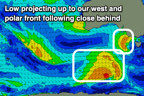
This morning the surf is smaller but cleaner in protected locations across the Surf Coast, and we should see a new W/SW groundswell building into the afternoon. Winds look to hold out of the W/NW for longer as well, with a low that's projecting towards us due to be positioned a touch more west, keeping winds favourable until late afternoon.
Size wise, the groundswell should build to 3ft+ later on the Surf Coast and 4-6ft on the Mornington Peninsula.
This weekend and next week (Jan 16 - 22)
 The low that's currently projecting into the south-east of South Australia and pushing east towards us is strong, but not well aimed at all through our swell window. As a result the additional close-range W/SW swell due later today will offer less size, and we'll be relying mostly on the inconsistent groundswell generated earlier this week for surf into this afternoon/evening and tomorrow morning.
Size wise, we should still see 3ft+ sets on the Surf Coast magnets early tomorrow, easing through the day with 4-6ft sets to the east. Conditions will generally be poor in all but protected spots though with a strong SW'ly, which looks to tend W/SW at times on the Surf Coast.
During the afternoon a secondary polar front will start edging into Bass Strait, generating some additional low-period SW swell later in the day.
On Sunday we'll see the stronger, mid-period energy filling in from the fetch of strong SW winds projecting from polar latitudes, up towards us today and tomorrow.
The morning looks to be around 2-3ft on the Surf Coast with the low-period energy from Saturday afternoon, with the mid-period swell kicking to 3-4ft late in the day (5-6ft on the Mornington Peninsula). Winds will remain an issue though, fresh from the SW in the morning, strengthening from the S/SW into the afternoon and evening as another front pushes up and into us. There's a chance for a lighter, W'ly wind early on the Surf Coast but in any case, protected spots will still be the go.
The front moving in Sunday should keep 3ft or so of mid-period SW swell on the Surf Coast Monday, 4-5ft+ to the east and winds look to back off and tend W/NW through the morning, creating cleaner conditions on the Surf Coast. Winds look to swing back to the SW late morning, strengthening into the afternoon, so get in before then.
This will signal the last of the polar fronts being projected up through our swell window before all the activity pushes east of Tasmania and out of our swell window. One final pulse of mid-period S/SW swell is due from this front into Tuesday, but with strong, poor S'ly winds which will abate slightly into the afternoon. Size wise the Surf Coast looks to lift to 3-4ft with 4-6ft sets to the east.
Winds are now looking a bit better later week with a high moving in quickly from the west, then being pushed north by polar fronts firing up south-west of WA. We should see a light E'ly develop Wednesday morning with easing surf from 3ft on the Surf Coast, 4-5ft to the east, smaller Thursday with winds possibly going N/NE. Friday looks dicey as a trough moves through and there'll be no swell left in the tank either.
Longer term, some S/SW groundswell may spread up from this polar frontal activity for next weekend with favourable winds, but more on this Monday. Have a great weekend!


Comments
Some good ones Sat midday.
Nice!
Looks like the wind was a better direction than forecast
The S/SW swell looks to have over-performed, I downgraded a little from Wednesday as the storm looked weaker and less favourable, but alas the magnets are seeing 4-5ft sets this AM! Looks great.
Yeah was surprisingly solid!
Some fun bottom turns and cutties today.