Large, strong swell this week, though the winds
Victorian Surf Forecast by Craig Brokensha (issued Monday January 4th)
Best Days: Experienced, keen surfers Thu and Fri AM, beaches Mon and Tue AM next week
Features of the Forecast (tl;dr)
- Large SW groundswell building late Wed, peaking Thu AM but with average conditions and light SE winds
- Easing SW grounswell Fri with morning E/SE winds
- Fun mid-period SW swell Mon/Tues with morning N/NE winds
Recap
Fun waves across selected beaches Saturday morning with a smaller mix of SE windswell and mid-period SW swell, not as favourable yesterday with less size and bumpier conditions.
Today the swell has come up with a mix of new SW swell and localised windswell though strong onshore winds are leaving no options for a decent wave.
This week and weekend (Jan 5 - 10)
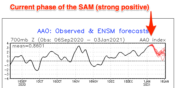
It's been a tough slog the past couple of weeks across the Victorian coastline, and we're at the peak of this positive Southern Annular Mode (SAM) event where the westerly storm track is pushed more polar, with high pressure dominating the mid-latitudes.
The SAM is expected to weaken but remain positive over the coming week or two, and this will see the handle of the high pressure and onshore winds loosened a little but until early next week we're not looking at any true offshore flow across the state.

Looking at the coming week though, and the mix of swells seen today will ease back tomorrow and surfing conditions will remain poor with strong S/SE tending S'ly winds.
Wednesday will be a write-off as well with fresh to strong S/SW winds and a further drop in size.
We then look at the large, long-period SW groundswell due Thursday across the state, with this actually showing later Wednesday, peaking Thursday morning.
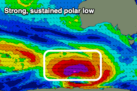
The strong polar low linked to the swell has developed and it's now positioned south-southwest of WA with a broad and elongated fetch of severe-gale to storm-force W'ly winds currently being generated through our swell window.
The low will continue east while weakening only slightly today, breaking down more so through tomorrow, though a smaller polar front will slide in behind the low, generating an additional fetch of W/NW gales.
 With the sustained fetch of severe-gale to storm-force winds, a large, long-period and powerful SW groundswell is due across the state, with the kick later Wednesday likely to see sets push to 3-4ft on the Surf Coast, 6ft to the east. A peak is due Thursday morning with 5-6ft sets on the Surf Coast swell magnets and 8ft on the Mornington Peninsula, easing through the day.
Conditions will be far from favourable with moderate to fresh S'ly winds blowing into the early morning, only easing at dawn and tending lighter SE. Winds will then freshen into the afternoon again from the S/SE-SE. This won't leave too many options with the large groundswell.
Friday isn't looking as favourable now with moderate E/SE winds due to continue across all locations (check back Wednesday for a final clarification) as the SW groundswell continues to ease back from 4ft on the sets across the Surf Coast, 5-6ft to the east.
Once the groundswell eases there's nothing of significance to back it up into the weekend and we'll see moderate to fresh S/SE winds creating poor conditions Saturday, lighter Sunday morning but with small, fading 2ft sets on the Surf Coast, 3-4ft to the east.
Moving into next week, we should finally see winds swing offshore out of the N/NE on Monday as an inland surface trough pushes east from South Australia. This will be with a fun, new mid-period SW swell, generated by a weak though broad and sustained polar front developing around the Heard Island region Wednesday.
The size from this front looks healthy with the Surf Coast due to come in around 2-3ft on the swell magnets, with 4-5ft sets on the Mornington Peninsula. Tuesday may offer a window of OK waves with stronger N'ly winds ahead of a change as the trough pushes east, but more on this Wednesday.

