Fun weekend with fading swell
Victoria Forecast by Craig Brokensha (issued Friday 20th November)
Best Days: Beaches mid-late morning tomorrow, beaches Sunday morning, Wednesday morning exposed beaches
Recap
Dawn started clean but fun across the exposed beaches yesterday with 3ft+ surf and inconsistent 2ft sets on the Surf Coast, but a strong pulse of new, long-period W/SW groundswell arrived shortly after, kicking in size through the morning and reaching 6-8ft on the Mornington Peninsula, with infrequent 3-4ft sets on the Surf Coast.
Conditions remained clean for the beaches and also improved across the Surf Coast reefs through the day as the swell held into the afternoon, though with long waits between sets. The surf ranged from good, excellent to calls of best ever across selected locations.

Hefty set yesterday (Alex Zadnik)
Today the swell has steadied owing to the longevity of the swell producing low, with clean 3-4ft sets on the Surf Coast, 6ft to the east, but an onshore change is now moving through creating deteriorating conditions.
This weekend and next week (Nov 21 - 27)
The moderate to large, long-period W/SW groundswell seen yesterday and today will ease off steadily tomorrow as the swell swings a touch more south-west in direction and drops in period.
This is because the final stages of the low generated weaker strong to gale-force winds, south-west of us.
Size wise, the Surf Coast should still see 3ft sets on the swell magnets, easing back to 2ft through the day and with 4-5ft sets to the east.
Conditions are looking better for the beaches tomorrow morning, improving mid-late morning as a dawn E/SE breeze shifts lighter E and even E/NE through the morning ahead of sea breezes. The Surf Coast will remain average with bumpy/lumpy surf.
The swell will ease further Sunday, back from 1-2ft on the Surf Coast and 3ft to the east and winds are tricky.
It looks like we'll see a dawn E/NE breeze, possibly swinging S/SE for a short period and then back N/NE later morning ahead of a shallow S/SW change. So don't expect perfect conditions but more so variable winds and slightly crumbly options at times on the exposed beaches.
Into Monday, our new, mid-period W/SW swell is due, though it'll be inconsistent and not offer too much size.
The swell was generated by a weak frontal system moving in behind the 'bombing low' linked to the current swell, but the lack of fetch strength and distance from us will result in a fairly mediocre swell.
Infrequent 2ft sets are due on the Surf Coast with 3-4ft+ sets on the Mornington Peninsula and it looks like winds will spoil the party as a stronger S/SW change moves through at dawn Monday, persisting Tuesday though fresh as the swell eases.
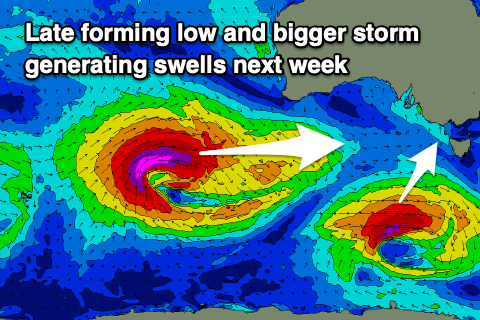
 As touched on briefly in Wednesday's notes, there's another strong low forecast to develop south-west of WA through early next week, though comparing it to this week's bombing system, it will be located a touch further north and west initially, but move more into our swell window through next week.
Size wise we're probably looking at a peak similar to that seen yesterday afternoon, but the winds look dicey and from the SE (more on this Monday).
Ahead of this a small low forming late in our swell window Sunday should produce a fun pulse of SW groundswell for Wednesday as winds swing back offshore from the N/NE. Size wise it's a good one for the beaches with 2-3ft sets due on the Surf Coast and 3-5ft to the east, fading through the afternoon with sea breezes.
Check back Monday for an update on Wednesday and Friday's swell and in the meantime, have a great weekend!

