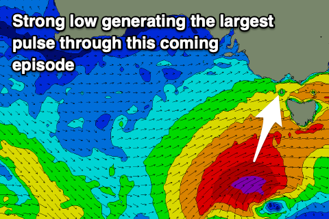
Renewal in swell to end the week
Victoria Forecast by Craig Brokensha (issued Wednesday 15th April)
Best Days: Protected spots Friday and Saturday, Sunday, Monday early on the beaches, Tuesday
Recap
Our reinforcing S/SW swell provided great waves across most spots yesterday with N'ly tending variable winds and easing surf from 3ft+ on the Surf Coast, 4ft+ to the east.
Today conditions are great again across the beaches but the swell small and to 1-2ft on the Surf Coast, 2-3ft to the east.

This week and early next (Apr 16 – 21)
A low point in swell is due tomorrow morning and with a morning W/NW breeze, there'll be nowhere to recommend for a surf. A strong SW change is due mid-morning and this will bring with it a local increase in windswell with a mix of inconsistent W/SW and SW groundswell from a distant storm earlier this week. Sets to 2-3ft are due to develop on the Surf Coast, 4-5ft to the east but with that poor and strong onshore wind.
Tomorrow's change will be linked to a good mid-latitude front moving in from the west, with it generating a fetch of strong W/SW winds through our western swell window yesterday and further today.
A moderate sized mid-period W/SW swell is due from this source, filling in Friday morning with waves to 3-4ft on the Surf Coast and sets to 6ft+ to the east. A further increase in swell is due through the afternoon, generated by a secondary and more favourably aligned front pushing up through our swell window on the back of the mid-latitude front tomorrow evening and Friday.
Building sets to 4-5ft are due later in the day across swell magnets on the Surf Coast, 6-8ft to the east, with our largest and best pulse of S/SW groundswell still on track for Saturday.
 This will be generated by a stronger low forming on the back of Friday's front, with a fetch of severe-gale SW winds due to be projected north-east towards Tasmania through our southern swell window.
The swell is due to fill in Saturday and peak through the afternoon (a touch smaller through the morning) with the Surf Coast kicking further to 6ft (possibly rare bigger cleanup) on the swell magnets, 6-8ft+ to the east on the sets. This is opposite to the trend shown in the forecast graphs as it's not resolving all the different swell soruces.
Coming back to the local winds, and with the secondary low forming on Friday, we'll see favourable and fresh W/NW-NW tending W winds through Friday, with Saturday seeing morning W/NW winds, shifting W/SW-SW late morning.
Sunday should see cleaner conditions develop east of Melbourne with a light and variable W/NW-NW breeze in the morning, shifting NE into the afternoon, clean through the morning on the Surf Coast with possible variable NE winds into the afternoon.
This will be with Saturday's easing S/SW groundswell from 4ft on the Surf Coast, 5-6ft to the east.
Moving into next week and the swell will continue to fade on Monday with strengthening N'ly winds ahead of a W/NW change, linked to a deepening and significant mid-latitude front come polar low moving in from the west, stalling south-west of Tasmania on Tuesday. With this a new moderate sized W/SW swell is likely Tuesday/Wednesday, but we'll have a closer look at this Friday.


Comments
Cheers Craig, a bit of something for everyone there. Got a few little grinders to myself after lunch, finally very quiet down this way.
Great to hear! Yesterday arvo looked so lush with the glassy conditions and fun sized swell.
Jeezus :o
Was that earlier in the week WAG? Looks to be a bit too big for yesterday. Not that I'm anywhere near the coast mind you...
Tuesday's S/SW swell.
Yeah that makes sense. Ta.
Yep, Tuesday arvo. My jaw hit the floor too, when I saw it :0
I can feel a flurry coming on....