Slow week, improving thereafter
Victoria Forecast by Craig Brokensha (issued Monday 23rd September)
Best Days: Saturday and Sunday mornings Surf Coast
Recap
Not much in the way of surf Saturday with the swell bottoming out ahead of a late increase in new W/SW groundswell but with onshore winds.
This swell provided fun waves in the 3ft range on the Surf Coast yesterday (odd bigger one swell magnets), bumpy and 4-6ft to the east and persistent NW winds.
Today the swell has backed off with fresher W/NW winds, only favouring protected spots on the Surf Coast.
This week and weekend (Sep 24 – 29)
This week will be slow and not ideal for surfing with the size slowly dropping away, at odds to the model guidance.
There hasn't been any significant storm activity in our swell window since the weekend and this will continue through the coming days, with just a small background mid-period W/SW swell tomorrow, and weaker S/SW swell for Thursday.
Size wise, the Surf Coast should still see inconsistent 2ft sets tomorrow on the swell magnets, 3ft+ to the east on the sets but a W/NW wind will only favour the Surf Coast, SW into the afternoon.
Wednesday looks even smaller, 1-1.5ft Surf Coast and 2ft+ to the east with an early W/NW breeze, back to the SW mid-late morning and S'ly into the afternoon.
Thursday looks the cleanest across exposed beaches with a morning N/NW breeze, but it'll be lucky to be 2ft, 1-2ft on the Surf Coast with the little pulse of S/SW swell.
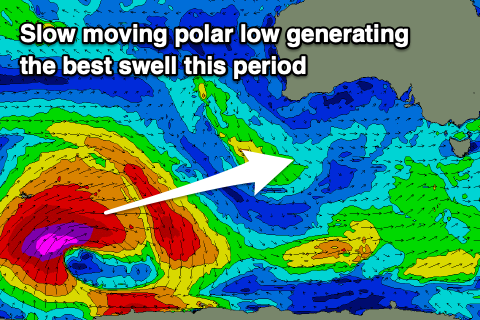
 As touched on last update we've got a better swell due this weekend, produced by a strong polar low forming in the Heard Island region yesterday afternoon.
This low is in our far swell window, but a great fetch of slow moving severe-gale to storm-force W/SW winds will be aimed towards us, weakening as it projects to a positioned south-west of WA tomorrow evening and further Wednesday morning.
The swell will be inconsistent but moderate in size, building later Friday but filling in more so Saturday and peaking through the day to an infrequent 3-4ft on the Surf Coast and 6ft on the Mornington Peninsula. There's the chance for the odd bigger cleanup at swell magnets on both coasts and winds are looking best for protected spots, light W/NW in the morning ahead of S/SE sea breezes.
Sunday looks to play out similar as the swell eases from 3ft and 4-6ft respectively across both coasts.
Moving into next week, and another tighter but intense polar low is due to form south-west of WA later this week, generating a briefer fetch of severe-gale to storm-force winds in our swell window, but in close proximity to us.
This looks to generate a slightly bigger, more consistent groundswell for Monday to 3-5ft on the Surf Coast and 6ft+ to the east with possibly onshore S'ly winds, but we'll have a closer look at this on Wednesday.


Comments
A whale carcass has washed up somewhere between gunna and St andrews apparently.
Keep a look out.
Thanks for the heads up PK.
Thanks PK for the heads up. Bit of a worry, though, as I was hoping for a surf at Gunna this Saturday. Conditions look okay.
Here's a link on the subject in today's Herald Sun. Looks like a juvenile whale. Anyone else have an update?
heraldsun.com.au/subscribe/news/1/?sourceCode=HSWEB_WRE170_a&dest=https%3A%2F%2Fwww.heraldsun.com.au%2Fleader%2Fsouth-east%2Fshark-sightings-rise-after-...
Hey Craig,
Gary noticed that the observations on the surf coast this morning were ever so slightly different to what was predicted in the notes. Do you expect that this slight difference will continue tomorrow and Thursday?
Likely but only by 0.5ft on what’s I’m expecting.
That's "6 inches" in Gary parlance.
And for Gary, every extra inch matters!
An extra 6in can be the difference between disappointment and a reeeal good time