Fun weekend, significant swell next week
Victoria Forecast by Craig Brokensha (issued Friday 6th September)
Best Days: Both regions Saturday, Surf Coast Sunday, Surf Coast early Monday, Wednesday and Thursday experienced surfers
Recap
A temporary drop in swell yesterday morning as we fell in between long-period swells and winds had a bit more north in them, but on the strong side for the Mornington Peninsula, better on the Surf Coast. The swell kicked through the morning back to 4-5ft on the sets across the Surf Coast swell magnets, while the afternoon was poor with a strong SW change.
Today winds have shifted back to the W/NW cleaning up all locations along with a reinforcing swell keeping the Surf Coast around 3-4ft, 4-6ft to the east.
Today’s Forecaster Notes are brought to you by Rip Curl
This weekend and next week (Sep 14 – 20)
The surf will ease a bit more in size and power into the start of the weekend, with today's reinforcing swell fading, slowed by a weak front pushing through this afternoon and evening, generating an additional mid-period swell.
3ft sets should persist across the Surf Coast magnets all day, 4-5ft to the east and winds will be favourable for all locations through the day. A morning W/NW breeze is expected to shift N/NE into the afternoon, opening up options to the east through the day.
A temporary low point in swell is expected Sunday morning, though likely not below 2-3ft and 4ft respectively across the Surf Coast and Mornington Peninsula with a fresh morning N/NW breeze.
Into the afternoon a mix of long-period W/SW groundswells are due, the first and least consistent produced by a vigorous frontal progression in the southern Indian Ocean this week.
The remnants of this progression are currently south-west of WA, with an unfavourable but strong fetch of severe-gale NW winds due to be generated in our swell window today, followed by a weaker fetch of W'ly gales early tomorrow.
Size wise, we should see the mix of W/SW groundswells building later Sunday afternoon, kicking to 3-4ft by dark on the Surf Coast and 6ft on the sets to the east. Winds will shift W/NW into Sunday afternoon with a possible late afternoon S'ly change, though we may see this delayed until near dark if we're lucky.
The remnants will strengthen south-west of us on Sunday, with a fetch of W/SW-SW gales generated through our southern swell window, producing a moderate to large sized SW tending S/SW groundswell for Monday and Tuesday morning.
Conditions won't be too flash though with fresh and gusty SW tending S/SW winds, likely W'ly early around Torquay Monday morning. Size wise the Surf Coast should see 4-5ft waves in the morning, possibly reaching 6ft on the sets into the afternoon, 6-8ft to the east.
Tuesday will see the S/SW groundswell easing from 4-5ft+ on the Surf Coast and 6ft+ to the east with less than ideal E/NE winds ahead of sea breezes.
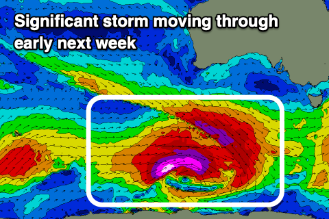
 Of greater importance is a very significant polar storm forming in the wake of the weekend's activity.
This storm will develop south-west of WA on Sunday, with a pre-frontal fetch of severe-gale W/NW winds priming the sea state for a post-frontal fetch of storm-force W/SW winds, tracking east along the polar shelf through our south-western swell window before passing under Tassie on Tuesday.
This is quite a significant storm and a large, long-period and powerful SW groundswell will be generated, building later Wednesday and likely peaking under the cover of darkness, easing slowly Thursday.
The swell is due to peak to 6-8ft+ on the Surf Coast and around the 10ft range on the Mornington Peninsula, but overnight, with later Wednesday likely seeing a strong kick to 4-5ft and 6ft to possibly 8ft to the east, easing Thursday from 6-8ft and 8-10ft respectively.
With the storm remaining at polar latitudes, winds will open up some interesting options for experienced surfers, gusty from the N/NE-NE Wednesday, stronger N/NE Thursday as it eases.
Following this a strong polar front come mid-latitude low through next week should generate a moderate to large W/SW groundswell for next weekend, but more on this Monday. Have a great weekend!


Comments
Don't get those winds and swell that often. One for the hell men...
Dunno what's going on at Torquay, but it's clean and overhead, and there's not a single surfer in the water. Couple out at Drainos, that's it.

Yes there are a few spots where you will need a bigger board. Should be impressive if you are there though.
Very ordinary atm, 2-3ft clean but close period, wonky windswell. The flat, weak faces aren't providing much opportunity for the contest at Bells :(
Yeah weak swell today.
What contest is that WAG? Looks like tomorrow will be a bit of a ball ache around Lorne area etc with the road closures for the ride.
Torquay boardriders. I couldn't even get motivated to get wet! Hope tomorrow is better.....
Hey Craig. Links from this page take us to Teahupoo's forecasts.
You might have been on the Teahupoo forecast before going here, hence the links mixing up.
Nope.. that's not it. something weird going on. No worries, I can still find my way back to where I want to be. :)
Torquay played Barwon Heads in the local footy Grand Final. The water was very quiet on Saturday
Swell kicked strongly late today as winds held, good to hear!
Just a heads up, the low linked to today and tomorrow's swell didn't quite evolve, stall and strengthen in the swell window, so we're not expected to see the size forecast above. Conditions are poor anyway.