Mixed weekend, better swells into next week
Victoria Forecast by Craig Brokensha (issued Friday 6th September)
Best Days: Surf Coast Sunday morning keen surfers, Surf Coast Tuesday, Wednesday, early Thursday
Recap
Good clean waves across the state yesterday, to 2-3ft on the Surf Coast and 3-5ft to the east, though a little lumpy and morning sick early.
Today winds were light and conditions morning sick again across most locations with a drop in swell back to 1ft to occasionally 2ft waves on the Surf Coast and 2-3ft to the east but full. Winds have already shifted NW and should clean up the Surf Coast ahead of an afternoon change.
Today’s Forecaster Notes are brought to you by Rip Curl
This weekend and next week (Sep 7 – 13)
We've got a mixed weekend of waves with weaker windy surf tomorrow, cleaner but on the ease Sunday.
There'll be no groundswell in the water tomorrow morning, with a strong mid-latitude low moving in and across us this evening forecast to generate a fetch of strong W/SW winds through Bass Strait. This will produce a weak windswelly increase in swell for tomorrow, coming in around 2-3ft in the morning on the Surf Coast, likely a little bigger into the afternoon. The Mornington Peninsula looks to build to a stormy 4-6ft through the day.
Winds will be favourable for the Surf Coast early and from the W, but strengthening from the W/SW through the morning.
Sunday morning will offer better conditions as winds swing back to the W/NW and ease, along with a mix of easing W/SW swell and S/SW groundswell. The groundswell has been generated by an elongated fetch of pre-frontal W/NW gales the last couple of days.
Size wise the Surf Coast will ease from 2ft to possibly 3ft early, 4ft+ to the east with W/NW-NW winds, shifting W/SW later in the day. A day for the keen.
 The change will be linked to a cold front moving in and across us, bringing a mid-period and weak increase in windy W/SW tending SW swell on Monday along with strong SW tending S/SW winds. No quality is expected with choppy and messy 3-4ft waves on the Surf Coast, 5-6ft to the east.
Tuesday looks cleaner as winds tip back to the W/NW in between fronts along with a drop in S/SW swell from the 3ft range on the Surf Coast.
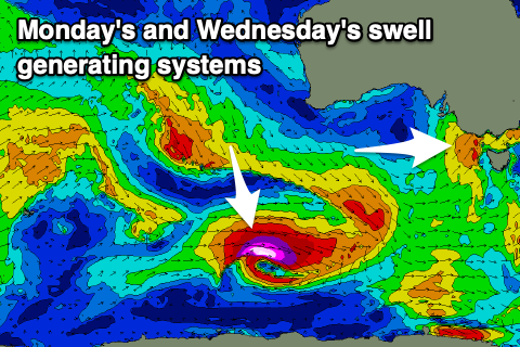
Later in the day and more so Wednesday we're looking at pulses of better long-period groundswell now, with a strong and deepening low due to form south-west of WA, generating a tight fetch of severe-gale to storm-force W/NW winds in our south-western swell window.
A moderate sized SW groundswell should be seen Wednesday, coming in 4-5ft on the Surf Coast and 6-8ft to the east with great offshore N/NW winds.
Another low forming on the back of this initial system may generate a secondary W/SW swell for Thursday but the models diverge on the strength of this system at the moment, with the more reliable EC being weaker.
Either way winds look to be favourable again out of the N/NW Thursday morning with a drop in size from Wednesday.
From here on the models go loopy, with GFS forecasting back to back vigorous and cold frontal systems pushing up and across us, generating large windy swells while EC is a little more subdued. This divergence is likely due to the models struggling to grapple the Sudden Stratospheric Warming event that's starting to filter down through the atmosphere, so check back here on Monday for a cleared idea for what's in store. Have a great weekend!


Comments
N/NW aint no offshore here Craigo
you need to give your self a bone and get off the hoax coast for a winter.
On another note - Sudden Stratospheric Warming event - what does this mean?
Check this out.. Stratospheric warming event
Therefore, a SAM + SSW = RSS
(Rat Shit Surf)