Fun tomorrow, slim pickings thereafter
Victorian Surf Forecast by Craig Brokensha (issued Friday 30th August)
Best Days: Exposed beaches tomorrow and Sunday for the keen, Monday through the day exposed beaches
Recap
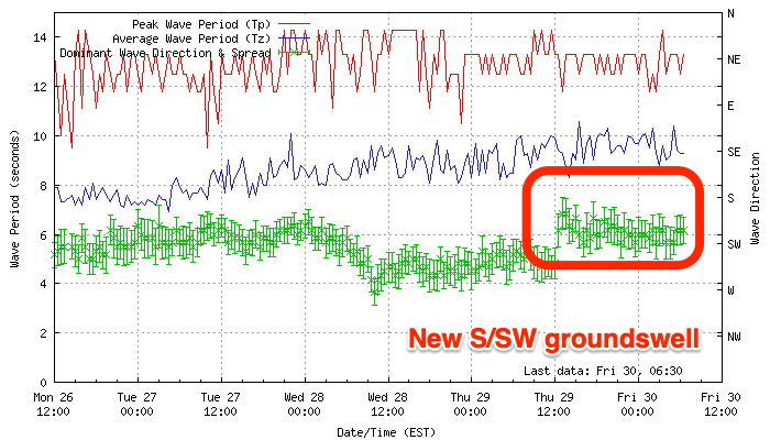
Poor conditions across most spots yesterday with a mix of easing groundswell and mid-period swell. A new S/SW groundswell has filled in this morning, with it showing up well on the new Cape Sorell wave spectrum yesterday evening (explained here). Conditions improved quicker than expected on the Surf Coastwith good cleanish 4ft waves and 4-6ft waves to the east.


Today’s Forecaster Notes are brought to you by Rip Curl
This weekend and next week (Aug 31 – Sep 6)
Today’s S/SW groundswell will drop back through the weekend and conditions will be great for the exposed beaches, but a little blowy at times. A fresh and gusty N/NE’ly is expected all tomorrow, a bit more N’ly on the Surf Coast at times with easing 2-3ft sets, around the 4ft range on the sets across the Mornington Peninsula.
Sunday will offer clean conditions again to the east but with stronger N/NE winds and smaller leftover waves to 2ft to maybe 3ft, small to tiny (1-2ft) on the Surf Coast. A NW change is now not due until later in the day with an approaching trough slowed a little.
As touched on the last couple of updates, the outlook isn’t great for next week as the storm track pushes north and up into WA, with weakened mid-latitude storms in the form of troughs and fronts dipping east-southeast through our western swell window. This doesn’t bode well for any significant size or power across the state.
Coming back to Monday, and Sunday’s late arriving trough will generate a weak fetch of W/SW winds in our western swell window that afternoon and evening. A very weak W/SW windswell only to 1-2ft on the Surf Coast and 2-3ft on the Mornington Peninsula is expected Monday, but there’ll be a slightly better but inconsistent W/SW groundswell in the mix.
The source of this swell was a slow moving fetch of W/SW gales, south-west of WA the last couple of days, and the Surf Coast doesn’t look to provide much over an infrequent 2ft for the most part, with the rare 3ft’er on the swell magnets, 3-4ft to the east.
One positive for Monday is that winds will improve for the exposed beaches during the day with a light to moderate early morning N/NW’ly due to swing N/NE through the morning, possibly holding through most of the afternoon east of Melbourne, but likely tending back N/NW later afternoon.
Winds will revert back to the NW on Tuesday following a westerly change overnight Monday as another weak front moves through, kicking up another spike in mid-period W/SW swell. The swell will have a touch more size compared to Monday’s windswell, but we’re only talking 2ft on the Surf Coast and 3-4ft to the east.
Wednesday looks clean again for the Surf Coast with the small mix of swells to a similar size under a fresh NW tending W/NW breeze, possibly shifting onshore later.
Later in the week we might see a bit more size and power to the swell as some stronger frontal activity develops to our west and south-west but the models diverge a little regarding the position and timing. Therefore we’ll have to have another look at this on Monday. Have a great weekend!


Comments
Will it be as blowy as last weekend as that was ridiculous?
Nah, not tomorrow.
Below average winter here? I was in Indo for a few weeks from late July (so wasn't keeping tabs on it) but since I've been back there hasn't been much of note (for the weekend warrior at least).
With winter just about over it would have to be one of the worst winters I can remember. Sure there's been some really fun days here and there and the surf coast seems to have had plenty of clean waves in the 2-4ft range but where have the large, raw winter swells been??
surf coast had a cracking summer , we can't have it all
Craig have you translated the obscured forecast notes into Latin? Well played if so.
In vino veritas