Good swell to end the week, cleanest on the weekend
Victoria Forecast by Craig Brokensha (issued Wednesday 28th August)
Best Days: Selected spots Friday, Saturday on the exposed beaches, Surf Coast Monday and beaches Tuesday
Recap
Fun clean 2-3ft waves on the Surf Coast yesterday morning, with today's new swell starting to show late and providing stronger and more consistent 3ft sets. The Mornington Peninsula was bumpy and average, better across Phillip Island.
Today the new SW groundswell is peaking with great surf around the 4ft range on the Surf Coast, 5-6ft to the east. Make the most of it before an onshore change moves through.
Today’s Forecaster Notes are brought to you by Rip Curl
This week and weekend (Aug 29 – Sep 1)
A trough bringing today's change will leave moderate to fresh S'ly winds, tending S/SE through the day and a drop in groundswell tomorrow. A new mid-period SW swell will fill in though, keeping the Surf Coast around 3-4ft, with 5-6ft sets on the Mornington Peninsula.
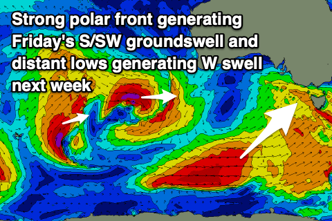
Our better S/SW groundswell for Friday is still on track, with a great polar fetch of W/SW gales that are currently south of WA due to project up east-northeast towards and under Tassie today.
 A good S/SW groundswell will be seen, peaking Friday morning with sets to 4ft+ on the Surf Coast and 6ft on the Mornington Peninsula as winds swing around to the NE through the morning. Local areas of N/NE winds are due and it won't be perfect after the onshore winds tomorrow. Locations handling the swell may be a little hard to find to the east, with the beaches the go to the west.
Winds will swing more E'ly into the afternoon, creating bumpy conditions, while Saturday looks the pick as the S/SW groundswell eases under fresh N'ly winds (N/NE east of Melbourne). Size wise the Surf Coast looks to ease from 3ft on the sets, 4ft+ to the east on the sets.
Come Sunday morning winds look to be out of the N again early but the swell smaller and back to 1-2ft on the Surf Coast and 2ft to possibly 3ft on the Mornington Peninsula. Winds will shift NW into the afternoon.
As touched on last update, a strong negative Southern Annular Mode (SAM) event will see the westerly storm track pushed further north into the end of the month/start of September, and this looks to be mostly focussed over towards Western Australia.
No major swell is expected for our region with the mid-latitude frontal/low activity due to dip east-southeast across us in a much weaker form through next week, producing small pulses of mid-period W/SW swell. There'll be some acute W'ly groundswell in the mix early next week as well from a slow moving low south-west of WA over the coming days, but size wise we're not looking at much over an inconsistent 2-3ft on the Surf Coast and 4ft+ on the Mornington Peninsula Monday, easing from a similar size Tuesday morning.
Winds will be best for the Surf Coast Monday and out of the W/NW-NW, possibly more variable and better for the beaches on Tuesday, as we'll be in between fronts. Wednesday may see strong N'ly winds and likely poor conditions as a vigorous front pushes in from the west but with no decent swell left. Later week some better W/SW swell may be seen from Wednesday's front, but more on this Friday.


Comments
Hey Craig/Ben, what does the spectral density on the cape sorrel buoy represent and how do you take this into consideration when looking at the surf eg. does it affect the consistency of the swell
Have you seen this article?
https://www.swellnet.com/news/swellnet-analysis/2019/08/29/new-dimension...