Tricky week with windy south swells for the weekend
Victoria Forecast by Craig Brokensha (issued Monday 5th August)
Best Days: Exposed beaches tomorrow morning, Surf Coast Wednesday morning, Surf Coast keen surfers early Friday
Recap
Fun waves across the Surf Coast all weekend with 3ft of swell Saturday morning, increasing into the afternoon and then coming in at 3-4ft on Sunday. The Mornington Peninsula was average Saturday but improved through the day Sunday as early cross-onshore winds straightened up and shifted more N/NE into the afternoon.
Today the swell was still a good 3ft on the sets across the Surf Coast, with workable waves to the east but to a smaller and similar 3ft or so on the sets.
Today’s Forecaster Notes are brought to you by Rip Curl
This week and weekend (Aug 6 - 11)
The weekend's mix of swells will continue to ease into tomorrow with sets dropping from a small 1-2ft on the Surf Coast magnets and 2-3ft on the Mornington Peninsula, easing further through the day. Conditions will be clean across both coasts tomorrow morning with local offshore winds (N/NW Surf Coast and N/NE Mornington Peninsula), and the afternoon will become tricky and not too flash with the easing swell as winds strengthen from the N/NE.
Looking at the outlook for the rest of the week and we'll see strong mid-latitude storms moving in towards us, but they'll mostly take a too northward track, not generating much in the way of swell for locations out of the wind, but lots of good quality snow.
 Firstly for Wednesday, a small mid-latitude low developing directly west-southwest of us tomorrow will project a fetch of strengthening W/SW gales in our western and then south-western swell window, with a spike in W/SW-SW swell due through Wednesday, peaking mid-late morning.
A kick in size to 3ft is due on the Surf Coast, 4-5ft on the Mornington Peninsula along with a morning W/NW winds, going variable sea breezey into the afternoon from the SE.
The swell will ease into Thursday morning along with a strong W/NW change (N/NW pre-dawn) associated with a trough moving through, weakening into the afternoon. The swell will be small and on the ease though from 2ft on the Surf Coast and 3ft to maybe 4ft on the Mornington Peninsula.
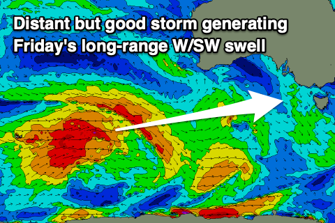
Moving into Friday a new inconsistent W/SW groundswell is due to fill in, generated in our far swell window by a storm that's currently between Heard Island and Western Australia. A broad and slow moving fetch of W/SW gales are being produced, with the storm continuing east before weakening under Western Australia tomorrow evening.
 A small to moderate sized and inconsistent W/SW groundswell is due from this source, peaking Friday to 3ft on the sets across the Surf Coast swell magnets and 4-5ft+ to the east. We'll see the remnants of this storm moving in from the west on Friday though, with a dawn W/NW offshore due to give way to a strong SW change as a deep low forms in Bass Strait.
The low will stall through Friday with a fetch of S/SW gales forecast to be generated in our southern swell window, directly off Tasmania's West Coast, into early Saturday morning as the low pushes north.
This will produce a moderate to large sized S/SW swell for Saturday, peaking through the morning to 4-5ft+ on the Surf Coast and 6ft to maybe 8ft to the east, but with poor and strong S'ly winds. Sunday will be a little better with fresh SW winds, possibly early W'ly on the Surf Coast but with easing 3ft waves on the Surf Coast, 4-5ft to the east.
Monday looks to play out similar wind wise, though with a greater chance for a morning W/NW wind on the Surf Coast along with a mid-period S/SW swell to 3ft and 4-5ft respectively. A larger and stronger long-period S/SW groundswell is expected to arrive later in the day, showing the most size Tuesday morning.
A strong polar low forming south-west of Tassie on Sunday will generate a great fetch of severe-gal to storm-force W/SW winds in our southern swell window as the storm projects slowly up towards the Tasman sea.
With the long-period nature and southerly direction, the Surf Coast is likely to come in around 6ft Tuesday morning, easing through the day with 6-8ft sets to the east. This depends on the track of the storm, with ECMWF having it further west resulting in more size but poorer winds on Tuesday. With the divergence we'll have to go over this again on Wednesday.


Comments
Not wrong about tricky, check 5 different sites and get 5 different wind forecasts for the end of the week!