Really fun days of surf to come
Victoria Forecast by Craig Brokensha (issued Wednesday 24th July)
Best Days: Surf Coast tomorrow and Friday morning, both locations early Saturday - Surf Coast from later morning, Surf Coast Sunday and Monday
Recap
Great conditions across the Surf Coast all day yesterday and across selected spots to the east with a slow increase in new long-period W/SW groundswell. The Surf Coast was 3-4ft, with sets showing to 5ft in the afternoon, though inconsistent and then kicking to 4-6ft by dark on the magnets.
The swell peaked overnight but we're still seeing great large sets on the Surf Coast this morning to 6ft on the magnets, larger to the east but best in protected locations. The swell will ease slowly into the afternoon but a reinforcing SW groundswell should keep 4-5ft waves hitting the Surf Coast, 6ft to occasionally 8ft on the Mornington Peninsula with persistent NW winds.
Today’s Forecaster Notes are brought to you by Rip Curl
This week and weekend (Jul 25 - 28)
The coming days will be really fun on the Surf Coast with the swell easing back further into tomorrow to 3-4ft, 5-6ft on the Mornington Peninsula, but a new W/SW groundswell is due into the late afternoon, holding all day Friday to a similar size.
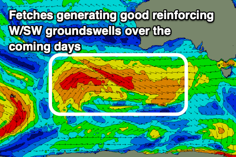
This is still and has been generated by a mid-latitude front passing under WA, with a fetch of W/NW gales projected through our western swell window.
 Conditions tomorrow will remain great for the Surf Coast with offshore NW winds, possibly tending more N/NW towards dark.
Friday morning will be clean again, but get in before lunch as a NW breeze will shift SW late morning.
The swell looks to ease a touch into Saturday from 3ft+ and 4-6ft respectively across both regions and we're now looking at an early N'ly breeze, shifting more NW through the morning and then W/NW into the afternoon.
Another reinforcing W/SW groundswell is due Sunday across the state, produced by a slimmer and more distant fetch of pre-frontal W/NW gales, followed by a small but strengthening post-frontal W/SW fetch.
An initial increase Sunday should keep 3ft+ waves hitting the Surf Coast and 4-6ft sets to the east, with the trailing fetch producing a slightly bigger swell for late in the day but more so Monday morning to 3-4ft and 6ft respectively.
Winds on Sunday will hold out of the NW, similar Monday ahead of a shift to the W/NW into the afternoon, shifting gusty S/SE on Tuesday in the wake of a trough as the swell eases.
Winds will continue to create poor conditions on Wednesday as the swell drops further, possibly lingering out of the SE Thursday with smaller, leftover waves. Longer term there's nothing too significant on the cards so make the most of the coming clean days.


Comments
After 6 months on the Gold Coast with mostly crappy very very crowded surf its a joy to get in the (bloody cold) water down the surf coast the last week with clean anywhere beteen 3-6 ft and only half dozen guys out and more to come, woo hoo!! Happy to put up with the cold for that! Aaarrrggghh still can't feel my feet this morning
That's great to hear!
your wetsuit needs upgrading if your feet are numb. if you can keep your core warm your feet and hands will feel cold but should not go numb.
Fully. Just go to Needs down the road.
What about Friday week? 6ft NE all day? That’s significant classification in my books.
(That E will surely turn a W no doubt)
Yeah there's a long-range W/SW groundswell on the way, but haven't looked at local winds.
Managed a solid window last Saturday looks similar this week Craig? Lighter winds I hope was difficult to get into with a massive tide and strong offshore.
ECMWF is a slight worry but I feel it will tend GFS's way, see what tonight's update has.
Oh my goodness, today was pumping!!! Great waves! Thanks again swellnet for the headsup. What a great winter down these parts! Yew!!
Stoked for ya!!
Cooking yesty..
Too crowded....
13th Beach looking clean and straight this AM.
