Excellent run for the Surf Coast
Victoria Forecast by Craig Brokensha (issued Monday 22nd July)
Best Days: Surf Coast every day, selected locations to the east later Thursday
Recap
Good waves across more exposed breaks and selected parts of the coast Saturday with a new W/SW groundswell easing from 3ft on the Surf Coast and 4-6ft to the east.
Yesterday started small and clean on the Surf Coast, bumpy to the east and a new W/SW swell spiked into the afternoon offering fun waves for those on the coast. The swell has eased back into this morning from a clean 2-3ft on the Surf Coast and 3-5ft on the Mornington Peninsula under fresh northerly winds.
Today’s Forecaster Notes are brought to you by Rip Curl
This week and weekend (Jul 23 - 28)
We've got a great week of waves ahead for the Surf Coast with a large, long-period W/SW groundswell followed by plenty of reinforcing energy and persistent offshore winds until Friday.
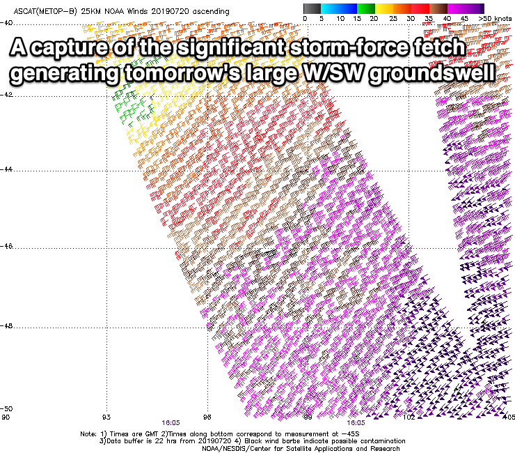
Over the weekend, a significant frontal progression developed south-west of WA, with a pre-frontal fetch of severe-gale W/NW winds setting in motion an active sea state for a stronger storm-force fetch of W/SW winds to move over, in our western swell window.
The frontal system is currently south of WA and continuing to aim a fetch of W/SW gales through our western swell window, with severe-gale W/SW winds in our south-western swell window (generating a reinforcing swell on the backside of the event Wednesday afternoon).
 We should see the swell building steadily all day tomorrow, starting from 3-4ft on the Surf Coast and peaking into the late afternoon to a large 6ft on the swell magnets (possibly the rare bigger cleanup), and 8-10ft on the Mornington Peninsula. The best thing about this progression is that all the storm activity will stay west of us, with persistent (though strong at times) NW-W/NW winds throughout near the whole week.
Tomorrow will see fresh to strong NW winds most of the day, possibly tending more W/NW later afternoon, and then W/NW-NW winds Wednesday as the swell eases slowly from 5-6ft and 8ft+ respectively across both regions.
The swell will drop a bit more into Thursday morning, but a new W/SW groundswell is due to build later in the day and peak Friday, generated by a good fetch of pre-frontal W/NW gales moving in and under WA over the coming days.
The Surf Coast will likely hang around 3-4ft Thursday and Friday with 6ft surf to the east, and with a NW tending N/NW breeze on the former, opening up a few more options and then N/NW winds early Friday ahead of a shallow SW change around midday.
The change will be linked to a weakening front moving across us, with winds reverting back to the NW on Saturday. Surf wise, the swell will ease just a touch more from Friday, but another storm strengthening south-west of WA later this week will produce another top up in W/SW swell for late in the day Saturday but more so Sunday.
We're looking at 3-4ft waves on the Surf Coast again and 5-6ft sets on the Mornington Peninsula with a W/NW tending SW breeze. Longer term the outlook slows down a little, so make the most of the coming run of surf.


Comments
Yewwwwwwwwwwwwwwwwwwwwwww
Amazing that the size still hasn't properly kicked yet. Significant wave heights at Cape Sorell are up around 6m, max wave heights are just shy of 10m (were almost 11m earlier this morning) and peak swell periods just nudged 20 seconds.
Although the synoptic scenario is way different (so the resulting surf can't be compared), those kinds of raw numbers on the North Shore would see maxing surf at Waimea.

It’s offical spoondrift has left the building
The swell was pretty big in Warrnambool today, much bigger than yesterday, with our offshore bombies breaking consistently. The west swell must be just taking a bit longer to wrap into Bells.
Seems to be a recurrent issue with these swells generated high up under the continent with a significant westerly aspect...seem to not really materialise to the extent expected. Maybe with a 20 second period it will start wrapping in more. At least that is my uneducated explanation.
BTW It was fun this morning though inconsistent.
I’d call it 4/6 ft and building @ 4.30 pm.
4ft+ sets in town in the fading light