Large surf to come, best in protected spots
Victoria Forecast by Craig Brokensha (issued Friday 12th July)
Best Days: Protected spots tomorrow morning, Sunday, Monday, Tuesday, Surf Coast through the end of the week
Recap
An increase in mid-period W/SW swell yesterday to a clean 3ft on the Surf Coast through the morning, building into the afternoon, though bumpy and windy.. while to the east, protected locations offered a few small waves for the keen.
This morning the swell has steadied around the 4ft range on the Surf Coast and 6ft to the east ahead of our next increase in size this afternoon and tomorrow.
Today’s Forecaster Notes are brought to you by Rip Curl
This weekend and next week (Jul 13 - 19)
Strong but zonal mid-latitude fronts have been pushing in from the west over the past few days, generating our current mix of W/SW swells, but the strongest of all the systems is now pushing up and towards us.
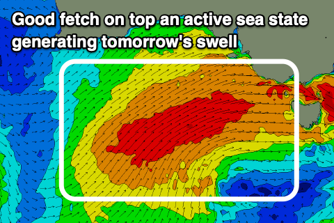
 A fetch of gale to near severe-gale W/SW winds are being generated, south of the Bight, with this fetch projecting towards us, on top an active sea state today before moving slowly east and across us this evening and tomorrow in a weakened form.
This will produce a large W/SW groundswell for tomorrow, peaking through the morning and coming in at a better angle than our current swells. The Surf Coast should see easy 6ft waves across the exposed reefs and beaches, with the high likelihood of 8ft cleanups, though not great on the morning high tide. It'll be larger to the east and best in protected spots.
Winds are looking better for the Surf Coast now, with local W/NW breezes likely through the morning, strong SW across all other locations. With these SW winds out into Bass Strait it won't be perfect, but decent for experienced surfers on the protected Surf Coast reefs.
The swell should start to ease into the mid-late afternoon, dropping back to 4-5ft on the Surf Coast magnets, 6ft to occasionally 8ft to the east. Winds will be great for the Surf Coast with a fresh W/NW-NW offshore in the morning, W'ly into the middle of the day, W/SW later.
Sunday morning's low point in swell will only be temporary though, with our secondary large SW groundswell due to start building into the afternoon, peaking Monday.
 The intense polar low linked to this swell has formed south-west of WA, with a fetch of severe-gale to storm-force W/SW winds currently being generated in our swell window. Unfortunately the low will race a little too quickly to the east and the push up and into us Sunday as a weaker front, escaping the swell it's generating.
This will limit the expected size, with a downgrade from Wednesday when it was expected to be slower moving.
We're now due to see the surf kicking Sunday afternoon owing to the front projecting a gale to severe-gale SW fetch up and across Tasmania Saturday evening and Sunday morning.
The Surf Coast should build to 5-6ft by dark, 8ft+ on the Mornington Peninsula but with that shift in wind to the W/SW.
Monday should reveal larger and fairly consistent 6-8ft waves across most exposed breaks, 10ft+ to the east and with fresh and gusty W/SW winds, unlikely W'ly early around Torquay, so try protected spots.
Tuesday will become cleaner across the Surf Coast reefs as winds swing back to the W/NW through the morning with easing sets from 4-6ft, 8ft to the east.
We've got a couple of reinforcing mid-period SW swells due through the middle to end of the week but these will just slow the easing trend in size with winds from the western quadrant.
Longer term there's a good W/SW groundswell on the cards for next weekend, but we'll go over this in more detail on Monday. Have a great weekend!


Comments
Looks like its snowing in Torquay.

Watch out on the Mornington Peninsula !
https://www.smh.com.au/national/victoria/stigma-isolation-the-flesh-eati...
I read that also this afternoon, crazy!! :o
Had one of these Ulcers on my foot for 12 months in 2013. Couldn’t surf for far too long. The experts knew very little and hypothesis as to what caused it changed frequently.
Heavy, all good now?