Large, windy swells inbound
Victoria Forecast by Craig Brokensha (issued Wednesday 10th July)
Best Days: Protected spots all period, only for experienced surfers on the biggest days
Recap
Tiny, clean offerings on the Surf Coast, with a touch more size but average conditions to the east. We may see a slight pulse of new W/SW swell this afternoon across the Mornington Peninsula but those strong N'ly winds will create average conditions.
Today’s Forecaster Notes are brought to you by Rip Curl
This week and weekend (Jul 11 - 14)
From tomorrow we'll see the surf increasing in size and power as a series of strengthening mid-latitude fronts move in from the west and across us. While the surf will become large, the strongest and best groundswell is due early next week, though more on this below.
Overall it looks like the models are over-forecasting the size on the Surf Coast with this upcoming event with a lot of windswell contamination, mixed in with the groundswell.
 Currently a vigorous mid-latitude front and low are moving in from the Bight, though sitting just in our western swell window, producing a fetch of strong to gale-force W/SW winds.
This front will move in and across us early tomorrow morning, with a burst of W/SW gales generated directly west of Bass Strait though tomorrow morning, pushing further east into the afternoon.
This will generate a building mid-period W/SW swell through tomorrow, likely building from 3ft to maybe 4ft on the Surf Coast swell magnets and 6ft to the east, up to 4-5ft on the sets later in the day on the Surf Coast magnets, and 8ft sets to the east.
A fresh to strong W/NW breeze will favour protected spots all day, and we'll likely see similar sized surf on Friday morning across both regions with strong W/NW tending W'ly winds.
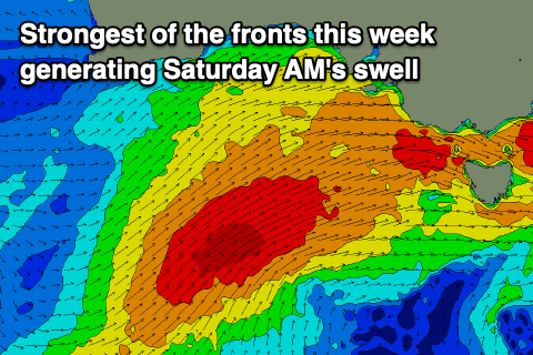
This shift in wind direction will be associated with the strongest of the storms moving in from the west this week, encroaching on the state. The front will project a stronger fetch of gale to near severe-gale W/SW winds towards us during tomorrow and Friday morning before weakening while moving across us.
A large and long-period W/SW groundswell is expected to be generated for Saturday, with an increase in size and power Friday afternoon to 4-6ft on the Surf Coast and a more consistent 8ft on the Mornington Peninsula. Saturday looks to come in at 6ft to possibly 8ft across the Surf Coast magnets and the 8-10ft range on the Mornington Peninsula beaches during the morning but with poor and strong onshore SW winds. There's a chance for an early W'ly around Torquay, but we'll have to confirm this on Friday.
 Sunday looks better as winds tend back to the W/NW through the morning, only fresh in nature, along with a drop in swell back to 4-5ft on the Surf Coast and 6-8ft to the east.
This will only be a temporary low point in swell with a large and long-period SW groundswell due to start building into the afternoon ahead of a peak on Monday.
The source of this swell will be a very intense polar low, forming south-west of WA on Friday and projecting a fetch of storm-force W/SW tending SW winds up and towards us during the weekend, weakening while pushing across Tasmania.
 With the extra south in the swell direction, stronger core winds (up to 55-60kt) and long-period nature, we'll see the Surf Coast peaking Monday to 8-10ft, with 10-12ft waves to the east. Conditions don't look great with a fresh, gusty and easing W/SW breeze, possibly W'ly for a period around Torquay, cleaner Tuesday as winds swing back W/NW and still large, but easing.
We'll have another look at all this swell on Friday though, so check back for an update.


Comments
No 50 year storm then. To Wind affected. !?
50 year storm? We've already had three this year!!! Which makes it a pretty standard year.
The comp. !
I love this sort of wild synoptic setup and the subsequent Southern Ocean swell that's inbound, Mother Nature is again, going to show us all who's boss around these parts, bring it on!