Fun tomorrow, good swell to end the week but with poor winds
Victoria Forecast by Craig Brokensha (issued Monday 12th November)
Best Days: Beaches tomorrow morning, beaches Sunday morning, both coasts Monday
Recap
Small clean 2ft leftovers for keen surfers on the Surf Coast Saturday morning, bumpy and average to the east.
Yesterday morning conditions were clean again with signs of new groundswell across both coasts, with the swell kicking strongly into the afternoon with fairly light and workable sea breezes.
This morning is the pick with good clean conditions across both coasts and 3-4ft+ sets on the Surf Coast with 4-6ft waves on the Mornington Peninsula.
Today’s Forecaster Notes are brought to you by Rip Curl
This week and weekend (Nov 13 – 18)
Our current groundswell will continue to ease over the coming days, dropping from a small 2ft tomorrow morning on the Surf Coast (if not for the odd sneaky bigger one at dawn) and 3-4ft on the Mornington Peninsula.
Winds look great for the beaches with a N/NE offshore, but we'll likely see winds go variable and more N/NW on the Surf Coast through the day and W/NW later across all locations with an approaching trough.
Wednesday looks average with no new swell and an early W/NW breeze on the Surf Coast, tending SW through the morning and more onshore into the afternoon.
 Our new westerly swell pegged for Wednesday afternoon and more so Thursday is now looking to come more from the SW and fill in Thursday with a peak into the afternoon. The onshore S/SE winds are also still expected though as a strong slow moving high moves in behind the trough on Wednesday evening.
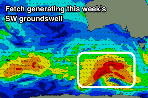
But coming back to the swell and a relatively weak cold front is due to develop south of WA this afternoon and evening with a fetch of strong to gale-force W/SW winds broadening into a better polar fetch of W/SW gales south-west of us and Tassie through tomorrow.
This should produce a fun sized SW groundswell for Thursday afternoon, with W/SW energy filling in early morning.
We should see the Surf Coast building to 3ft+ into the afternoon (4ft bombs at magnets) with 4-6ft sets on the Mornington Peninsula but with a poor and gusty S'ly tending S/SE breeze.
Friday should ease from a similar size but winds will remain average and out of the S/SW-SW. There's a very slim chance that there may be a dawn W/NW'ly around Torquay with a funky trough in the region, but we'll have another look at this on Wednesday.
The weekend will start average as the swell continues to ease and the high moves east swinging winds back to the SE Saturday.
Sunday is looking clean on the beaches to the east with a NE offshore, and a new mid-period SW swell should provide some fun sized sets.
This and a slightly stronger pulse for the afternoon and Monday morning will be generated by relatively weak but persistent polar frontal activity through our swell windows.
Size wise the Mornington Peninsula should offer fun sets around 4ft, with smaller 2ft+ waves on the Surf Coast, similar though slightly stronger Monday as winds tend more N/NE. We'll have another look at this Wednesday though.


Comments
Howdy Craig,
You’re always spot on with your localised wind forecast for Torquay, but how do you do it? Is it a complex interpretation of or is there a magical source online? If it’s a secret then never mind, but if not i’d love to know.l so I can impress myself.
Thanks.
I can't give all my secrets away but the hi-res modelling for the Australian coast is pretty spot on, though some sites you have to pay for it. I use this as well as looking at the varying forecasts between each model and also some local knowledge from years of looking at each region.
Well thanks, super appreciated and essential stuff.
Nice lines still pouring through the open beaches, even though the swell is easing.

Still some lovely lil' lines along the Bellarine beachies.

Sure did easy quickly today though.