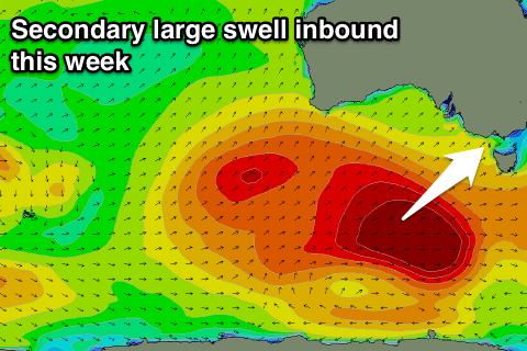
One more large swell to come but winds are touch and go
Victoria Forecast by Craig Brokensha (issued Monday 5th November)
Best Days: Surf Coast early tomorrow, Surf Coast Wednesday, Thursday and Friday mornings
Recap
The weekend went pretty much bang on forecast. Building levels of strengthening mid-period W/SW swell through Saturday around 3-4ft and clean through the morning on the Surf Coast, becoming larger through the day as winds held until about mid-afternoon. Later in the day (photo below) solid 5-6ft+ sets were hitting exposed breaks with a bit of bump and lump, but come Sunday our large new S/SW groundswell pushed in strongly.

While a little slow on the morning high tide, the dropping and then incoming tide saw easy 6ft+ sets across most breaks on the Surf Coast with 8ft cleanups under light winds which turned onshore though without much strength mid-afternoon. Locations to the east were large and options limited.
Today the S/SW groundswell is on the ease, dropping fro 3-4ft on the Surf Coast and 5-6ft on the Mornington Peninsula. Early N'ly winds have since shifted NW and should hold out of the W/NW this afternoon, if not tend variable.
Today’s Forecaster Notes are brought to you by Rip Curl
This week and weekend (Nov 6 - 11)
The weekend's W/SW and S/SW swells were the first generated under the influence of a strong node of the Long Wave Trough sitting just west of the Bight.
Over the weekend another vigorous polar low formed under its spell, south-west of WA with a great fetch of severe-gale to storm-force W/SW winds projected through our south-western swell window.
 The storm has since weakened, with a large long-period SW groundswell now heading towards us, with it due to arrive tomorrow morning and peak through the day.
The Surf Coast magnets should build to a strong and powerful 4-6ft on the sets (likely slightly under sized early), with 8ft bombs on the Mornington Peninsula.
Winds are a touch dicey though look mostly variable but could go S/SE by mid-morning across all locations ahead of a more pronounced SW change into the afternoon. Therefore don't expect conditions to be as pumping as the last day or so.
Come Wednesday a morning W/NW offshore should favour the Surf Coast reefs, swinging W/SW-SW later morning.
Size wise the Surf Coast should still see good sets easing from 3-4ft with 6ft sets on the Mornington Peninsula, while into the afternoon and more so Thursday morning a mix of reinforcing mid-period W/SW and SW swells are due.
These are currently being generated by a polar fetch of strong SW winds on the tail of the strong long generating tomorrow's swell, with a front also projecting W/SW winds through the Bight and our western swell window this afternoon and tomorrow.
These swells will fairly weak in comparison to the recent energy and come in at mostly 3ft on the Surf Coast, with the odd 4ft bomb at times through the day, and 5-6ft on the Mornington Peninsula.
The Surf Coast will be the pick again with a morning W/NW breeze, tending back to the SW later morning, with better offshore NW winds Friday as the swell eases back from 2-3ft.
Into the weekend there's nothing too major due with a small mid-period W/SW swell due to build Saturday afternoon and peak Sunday, generated by weak unconsolidated frontal activity in our medium-range swell window.
Winds look to favour the Surf Coast with morning W/NW-NW winds, but size wise there's not much to it with small 2ft waves max, 3-4ft to the east. A slightly stronger swell may be seen Monday, but we'll review this Wednesday.


Comments
Craig likes Cathedral
Gotta go to church on Sunday's.
Thanks for the info Craig. What do you reckon the wind speed will in the morning if it does go S/SE?
Latest updates have it likely to not occur now so you should be sweet!
Hey Craig. As there is no movement on the Sorell Bouy as yet, will the new swell be starting to show at dawn tomorrow?
Here's an idea! Maybe take the punt,get up in the dark, drive to the beach and check it yourself in the pre-dawn light!
Or is that too hard in 2018...........you gotta ask a bloke from Sydney to spoon feed you before you commit.
Farkinhell..........
Another hefty swell today. Reports of large powerful sets to 6ft+ at Bells/Winki with a couple of 8ft cleanups.
Sick! What a great little November run,
Spewing I'm at work today but at least it looks like the conveyer belt is pretty active until mid next week.
Cape Sorell wave period went nuts about midnight for early Tuesday AM
Tired and happy, I reckon a lot of people are.
How good. Ah will get those charts for you tomorrow re what generated the best of the swell.