Workable on the Surf Coast, much better next week
Victoria Forecast by Craig Brokensha (issued Wednesday 5th September)
Best Days: Surf Coast Friday and Saturday morning, Surf Coast Monday, all regions Tuesday, Surf Coast Wednesday morning
Recap
A good reinforcing SW swell keeping 3ft to occasionally 4ft waves hitting the Surf Coast through yesterday, with favourable winds for both the beaches and reefs in the morning, best on the beaches into the afternoon. The Mornington Peninsula and Phillip Island were great with clean 4-5ft waves through the morning, smaller later.
The swell has dropped back a fair bit this morning to a small 2ft on the Surf Coast and 2-3ft on the Mornington Peninsula with favourable winds for the beaches.
Today’s Forecaster Notes are brought to you by Rip Curl
This week and early next week (Sep 6 - 11)
The surf will continue to fade this afternoon, bottoming out through tomorrow with tiny to flat surf expected across all locations.
A mix of the early high tide and N/NE wind will leave no surfing options, even on the exposed beaches tomorrow morning, while winds will shift W/NW into the afternoon with a possible late kick in new long-period W/SW groundswell.
Any increase in size will only be small to tiny on the Surf Coast in any instance.
Moving into Friday we should see our long-period inconsistent W/SW groundswell filling in, with a late pulse of closer-range but now smaller W/SW swell.
The long-range energy has been generated since late last week in the southern and south-east Indian Ocean, with this expected to build to an infrequent 3ft on the sets across swell magnets on the Surf Coast through the day, and 4-6ft to the east.
The close-range swell generated by the remnants of the storm pushing east has been downgraded, with only a small weak fetch of strong to near gale-force W/SW winds expected to be generated through our swell window.
 This swell will only arrive late in the day and not push above (in size) the infrequent W/SW groundswell, easing through Saturday.
W/NW winds should favour the Surf Coast all day Friday, though expect waits for the sets, while Saturday should see easing surf from a similar size to Friday afternoon with a persistent NW offshore.
Sunday will be smaller and W/NW winds will continue to favour the Surf Coast but with small 2ft waves through the morning, possibly building later in the day, but our new swells are now due more into early next week.
A relatively weak polar front is due to produce a mid-period W/SW swell for Monday morning, forming in the Heard Island region today and producing a distant fetch of W/SW gales before weakening while pushing under the country.
We're likely looking at 2-3ft waves on the Surf Coast and 4-5ft sets to the east Monday morning, ahead of a stronger and larger long-period W/SW groundswell arriving mid-late morning.
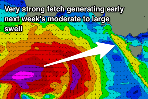
This swell will be generated by a much stronger storm developing further north in our western swell window, producing a fetch of severe-gale to storm-force W/SW winds south-west of WA Friday and Saturday before dipping south-east while passing under the Bight.
We should see this swell building rapidly through Monday and reaching 4-6ft on the Surf Coast with 8ft sets on the Mornington Peninsula.
Winds look excellent as the storm dips south-east, blocked by a high resulting in moderate to fresh NW tending variable breezes.
The swell should ease through Tuesday under a fresher N'ly offshore, favouring most breaks, but we'll review this Friday.


Comments
are you still expecting WNW winds all day tomorrow craig looks a bit dicey now
cheers
possibly answered your own question there nick. Try bom Geelong.
Craig’s probably at home having dinner with the kids mate.
NAH, spoon feed me! I want to know, exactly where, when and what you think I should do because I'm an advanced to expert surfer from far away, with a hypocrypto under my arm and I dont wanna waist my precious time fluffing about.