Fun beachy waves tomorrow, larger windier swells for the weekend
Victoria Forecast by Craig Brokensha (issued Wednesday 29th August)
Best Days: Both coasts Thursday, Friday afternoon Surf Coast, Saturday morning Surf Coast, both coasts Monday morning and Tuesday
Recap
Much better waves yesterday with lighter and more variable offshore winds across both coasts with some slight lump and bumpy early. The Surf Coast eased back from 2-3ft, with 3-5ft surf to the east, smaller this morning but cleaner across the exposed beaches.
A new long-period SW groundswell is due to arrive later today with weak E/SE sea breezes.
Today’s Forecaster Notes are brought to you by Rip Curl
This week and weekend (Aug 30 – Sep 2)
The new long-period SW groundswell due later today should peak overnight/early tomorrow and ease off slowly through the day.
The swell will be a little inconsistent but should provide good surf in the 3ft range on the Surf Coast (odd bigger one at magnets) and 4-6ft sets on the Mornington Peninsula under a moderate to fresh N/NE breeze. This will favour the exposed beaches across the state.
Friday looks small and only suited to keen surfers with an early N'ly breeze, tending NW through the morning and W/NW into the afternoon.
A new S/SW groundswell is due to fill in through the afternoon and hold Saturday, produced by a polar fetch of W/NW gales, followed by W/SW gales.
 The W/NW fetch will generate Friday afternoon's increase, with the Surf Coast due to reach 3ft on the sets, with 4-5ft+ waves to the east.
The trailing W/SW fetch should keep similar sized sets hitting the state on Saturday morning, and an afternoon increase shown on the models isn't likely in my opinion.
The Surf Coast will be cleanest on Saturday with a morning W/NW breeze, swinging W/SW-SW into the afternoon.
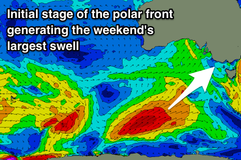
This change will be linked to a vigorous polar front projecting up and across Tasmania, bringing with it a large SW tending S/SW groundswell.
We'll see the polar front form south-southwest of WA tomorrow afternoon projecting a fetch of SW gales up through our south-western swell window before passing under Tassie Saturday evening through our southern swell window.
A large SW tending S/SW groundswell should be seen, filling in through Sunday and peaking into the afternoon. The Surf Coast is expected to reach 5-6ft, with 8ft surf on the Mornington Peninsula, but as touched on in the last couple of updates, winds look generally poor and out of the S/SW in the wake of the swell producing front clipping the state.
There's an outside chance for a dawn W/NW wind around Torquay, but we'll review this Friday.
Monday is looking cleaner though still likely lumpy with a light variable breeze and easing S/SW swell from 4-5ft on the Surf Coast and 6ft to possibly 8ft to the east.
Looking further into next week and a strong long-period S/SW groundswell is due to fill in Tuesday, produced by a vigorous polar low forming late in our swell window, south-west of Tassie over the weekend. At this stage we're looking at good 3-4ft sets developing across the Surf Coast Tuesday with 6ft surf to the east under N/NE winds, but more on this Friday.


Comments
I really hope that swell eases slowwwwwwwwwwly tomorrow..
Yeah makes it past the low tide ay Nick..
been talking to A.Z lately?
Yeah, why's that.
your last comment about a right on social media down this way. im putting two and two together and assuming this was on his intragram or facey?
Haha, basically, thought not his vid I saw.
Hey Craig,
Whats your thoughts on 13th saturday morning with the W/NW fetch? anyone got any comments on how 13th has been this season?
dave
I wouldn't be worried too much about how the swell performs, it's the winds that will likely spoil your morning.
its been shite Dave. banks are shit, nw and westerly winds shit. Much better spots to head to.
thanks for the heads up
be a good weekend to hit up UrbnSurf in tullamarine!
Any word on when that's going to be up and running? Started development yet?
tipping they have not even scratched the dirt yet...
I figured that might be the case. I'm skeptical about whether it will ever go ahead.
I have been a little bit involved in the development of the project, construction is well underway, mainly excavation for the water bed. Opening month still on target April 2019. I have spoken with the PM.
Get excited lads!
On track! Good to hear. Maybe that’ll keep a few away from the coast and in the concrete jungle.