Swells from the south-western quadrant with winds from all directions
Victoria Forecast by Craig Brokensha (issued Monday 27th August)
Best Days: Both coasts tomorrow, exposed beaches Wednesday and Thursday (the pick of the week), Surf Coast Saturday morning
Recap
Great waves all weekend with clean conditions across both coasts on Saturday and a good reinforcing SW groundswell in the 3ft range west of Melbourne, 4-5ft+ to the east.
Winds shifted more west and less favourable for the beaches east of Melbourne yesterday, but the Surf Coast remained super fun with similar amounts of swell.
A cold front and onshore change due today has come in as expected with poor conditions across all locations.
Today’s Forecaster Notes are brought to you by Rip Curl
This week and weekend (Aug 28 – Sep 2)
The polar front linked to today's onshore change will combine with a surface trough off the East Coast and form into a deep Tasman Low to the east of Tasmania this afternoon and evening.
With the low forming further east of us we'll see winds improve tomorrow and tend variable across all locations. With this there may be a bit of lump left through the morning. The swell will be on the weaker side, with a mid-period SW swell that should be in the mix today due to ease back from 2-3ft at magnets on the Surf Coast, 4ft on the Mornington Peninsula.
Wednesday will be great across the beaches with a N/NE offshore, but the swell will be weaker and struggling to reach 2ft on the Surf Coast, and 3ft on the Mornington Peninsula.
Our new long-period SW groundswell due into the late afternoon and more so Thursday is still on track.
This swell was generated over the weekend by a vigorous polar low forming south-west of WA. A fetch of severe-gale to storm-force W'ly winds were generated in our swell window, with the low currently breaking down south-southwest of WA.
We should see the long-period forerunners arriving through Wednesday afternoon with a late kick in size likely with what looks to be E/SE winds. We're only looking at maybe 2ft+ sets on the Surf Coast on dark and 4ft waves to the ease.
 The swell is due to peak overnight and ease steadily Thursday from an inconsistent 3ft at swell magnets on the Surf Coast and 4-6ft to the east.
Winds will be great for the beaches all day though with a gusty N/NE offshore, likely becoming strong at periods through the day. This should create a fairly full day of good waves on the magnets though.
The strengthening northerly wind will be linked to a broad and strong mid-latitude low moving in from the west, but this system will be positioned inland and bring no meaningful swell to us at all.
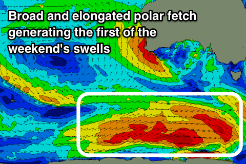
A flurry of strong and elongated polar fronts will produce good swells from the weekend, the first for Saturday, with a larger windier swell for Sunday.
Saturday's swell will be produced by a great pre-frontal fetch of W/NW tending W and then W/SW gales passing far south under the country mid-late week.
We should see a good long-period SW tending S/SW groundswell from this system arriving overnight Friday and peaking Saturday to 3-4ft on the Surf Coast and the 6ft range to the east. The Surf Coast is shaping up best with a W/NW tending SW breeze.
Into Sunday a larger SW groundswell should be seen, generated by a secondary vigorous and broad polar front forming south of WA and projecting north-east up towards Tassie through Friday and Saturday.
Winds will swing onshore out of the S/SW with the front clipping the region as the SW groundswell peaks in the 4-5ft+ range on the Surf Coast and 6-8ft on the sets to the east. Offshore winds are likely as the swell eases Monday, but we'll have another look at this Wednesday.


Comments
Think I have spotted condition Brown Trousers about a week into September on the WAMS...
Missed it, not there this morning :)