Very slow forecast period
Victoria Forecast by Craig Brokensha (issued Friday 20th April)
Best Days: Swell magnets keen surfers Saturday and Sunday mornings, east of Melbourne Monday morning and dawn Tuesday
Recap
Good fun waves across all locations yesterday with sets hanging in the 3ft range on the Surf Coast and 3-5ft on the Mornington Peninsula, easing into the afternoon with weak sea breezes.
This morning we're back to the small stuff with slow waves across all spots, best on the open beaches across the Mornington Peninsula.
Today’s Forecaster Notes are brought to you by Rip Curl
This weekend and next week (Apr 21 - 27)
The weekend and more so this forecast period isn't looking too flash, with the swell bottoming out tomorrow leaving hardly any size even on the exposed breaks.
The Surf Coast will be tiny, with the odd 2ft set due on the Mornington Peninsula. A light NE tending variable N breeze will create clean conditions ahead of afternoon sea breezes.
Our very inconsistent long-period W/SW groundswell for Sunday afternoon and Monday is still on track and winds are looking more favourable for the exposed beaches which is great, as the Surf Coast will hardly see any size.
The swell was produced by a very strong and prolonged storm forming south of South Africa last Sunday, pushing eastwards through the Indian Ocean this week.
This swell isn't ideal at all with it being extremely inconsistent, west in nature and small, but In the absence of any other swells, it's all we have.
We should see a slow increase in size Sunday, building from 2ft do 3ft+ later in the day (tiny on the Surf Coast). A peak should be Monday to 3ft to occasionally 4ft on the Mornington Peninsula and maybe 1-2ft at Surf Coast magnets, but i'd keep your expectations very low.
Winds on Sunday morning will be variable creating clean conditions ahead of afternoon sea breeze as the swell builds, while Monday looks fun on the beaches with a morning E/NE-NE breeze ahead of sea breezes.
 The swell will ease through Tuesday and early N'ly winds will favour the exposed beaches, swinging more NW into the afternoon.
From here there's no new swell expected until later in the week owing to mid-latitude lows in the Bight and off WA blocking our main swell windows.
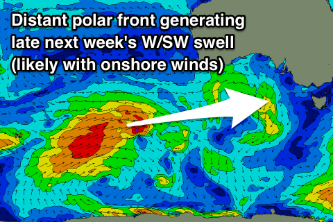
We'll see this break down through next week, with a strong but weakening polar front due to move through our western swell window Sunday through Tuesday before possibly restrengthening a touch west of Tassie mid-next week.
Either way we'll only start to see an increase in size through late Thursday and more so Friday and into next weekend.
Winds are unfortunately looking suss at this early stage as a low deepens off the East Coast, directing onshore breezes into us, but we'll have a closer look at this Monday. Have a great weekend!


Comments
hey craig do you think there will be any surfable waves on the reefs or only at 13th
When? Not really, it's very average until late next week.
pessimistic forecast at best craig ! my models are showing a great north westerly groundswell that should make landfall by dawn.
You meant crowdswell?
whats tomoz looking like?? seaweed saying 2-4ft at bells of 1.5ft at 19s ???
youve got it at 0.8ft at 19??
It's there in the notes.
youve got 2-3ft on mornington not surf coast... your saying 1ft on SC in the notes
Yeah, 1ft. MSW uses face feet so 2-4ft is 1-2ft. I doubt it will get to 1-2ft.
Tricked.....by msw...!