Fading weekend surf, tons of swell next week but with average winds
Victoria Forecast by Craig Brokensha (issued Friday 9th March)
Best Days: Swell magnets tomorrow morning, Surf Coast next Thursday
Recap
Good waves across most locations yesterday with a fun new S/SW groundswell building to 3ft on the Surf Coast and 4-5ft on the Mornington Peninsula with a couple of bigger bomb sets.
This morning the swell was a bit smaller, easing from 2ft to occasionally 3ft on the Surf Coast and 3-4ft on the Mornington Peninsula with light favourable winds again this morning.
Today’s Forecaster Notes are brought to you by Rip Curl
This weekend and next week (Mar 10 - 16)
The coming weekend isn't going to offer much in the way of surf.
We'll see our current easing S/SW groundswell continuing to fade through tomorrow, dropping from a tiny 1ft+ on the Surf Coast and the 2ft range on the Mornington Peninsula. The early high tide won't be ideal, so a mid-late morning paddle will be best.
Conditions should be great with light local offshore winds until mid-afternoon.
Come Sunday the swell will bottom out and a dawn W/NW breeze will give into a SW change through the morning.
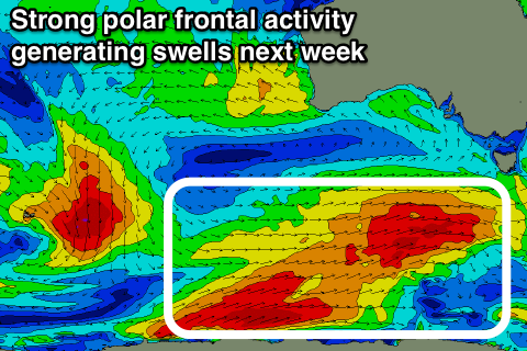
This change will be linked with the first of a series of vigorous polar fronts firing up under the influence of a strong node of the Long Wave Trough stalling across us early next week.
 We'll see back to back pulses of moderate to large SW groundswell through next week, the first building through Monday.
This will be generated by an initial strengthening polar front forming south of WA tomorrow expected to project a fetch of gale to severe-gale W/SW winds towards and then under Tassie.
A moderate to large sized SW groundswell is expected to start building later Monday, peaking Tuesday to a good 4-5ft on the Surf Coast and 6ft to occasionally 8ft on the Mornington Peninsula.
A secondary front will generate a more polar front will produce a fetch of gale to severe-gale W/SW winds Sunday and Monday, producing a secondary pulse of S/SW groundswell for Wednesday to a similar size on both coasts.
We'll see the surf ease back a touch through Thursday but a third broad but slightly weaker front pushing in early-mid next week should generate a reinforcing swell, slowing this easing trend.
Into the end of the week we may see one final polar front pushing up and into us, generating a large S/SW swell Friday/Saturday, but we'll have another look at this Monday.
Coming back to the local winds and onshore S/SW-SW breezes look to persist Monday through Wednesday while slowly weakening. The chance of early W/NW winds around Torquay early each morning look minimal but we'll reassess this Monday. Thursday is looking the cleanest, but have a great weekend!

