Great few days of surf ahead
Victoria Forecast by Craig Brokensha (issued Wednesday 20th December)
Best Days: Surf Coast Thursday morning, both regions Friday morning and Saturday morning, Surf Coast possibly dawn Sunday
Recap
Fun small waves across the exposed beaches east of Melbourne with clean 2ft sets before a strong W'ly change whipped through.
This morning we've got tiny clean waves on the Surf Coast and slightly bigger but poor conditions on the beaches to the east. The Cape Sorell wave buoy has shot right up, though this initial spike in swell is from pre-frontal NW gales around a severe low, and won't translate to any swell on our coast this morning. Of more significance is the fetch of W/SW-SW winds wrapping around the northern flank of the low generating a kick in swell this afternoon, discussed in more detail below.

Today’s Forecaster Notes are brought to you by Rip Curl
This week and weekend (Dec 21 – 24)
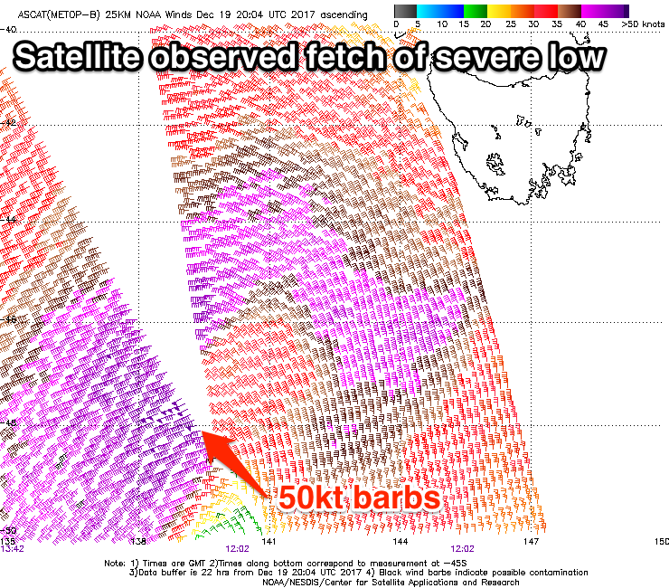
 A severe low is currently sitting south-west of Tassie, with a pre-frontal fetch of gale to severe-gale NW winds (aimed away from our swell window) being followed up by a more significant fetch of severe-gale W/SW-SW winds. Satellite observations have picked up a couple of storm-force barbs which will persist in our south-western swell window as the low dips south-east under Tassie during today.
The swell from this low has been upgraded a touch, with a strong kick in size expected later today to 3-4ft by dark on the Surf Coast and 6ft+ on the Mornington Peninsula as winds swing to the W/SW.
A peak in swell is expected overnight, but the Surf Coast should offer great 4ft sets tomorrow morning with a W/NW offshore, and 6ft to possibly 8ft sets on the Mornington Peninsula, easing slowly through the day as winds swing onshore.
The swell should continue to ease into Friday morning from 3ft and 4-5ft+ respectively as a morning NW breeze again favours the Surf Coast. A more variable breeze is likely across locations east of Melbourne, opening up fun waves across select locations.
Our secondary pulse of reinforcing SW groundswell for the afternoon is still on track, with a strong polar front developing on the backside of the severe low today, south of WA.
We'll see a fetch of gale to severe-gale W/SW winds moving towards Tasmania, generating a great new SW swell that should build back to 3-4ft on the Surf Coast Friday afternoon and 6ft+ on the beaches to the east.
 Those favourable morning winds will give into S/SE sea breezes as this swell fills in.
The swell should hold into Saturday morning though with similar sized surf under light local offshore winds (NW Surf Coast and N/NE Mornington Peninsula).
Another front approaching from the west will swing winds more westerly through the day and onshore into the afternoon as the swell eases.
We'll see the surf continuing to ease Sunday but still up around 3ft on the Surf Coast during the morning and 4-5ft+ to the east, though a weak cold front and high pressure system moving in from the west will bring an onshore SW change. The timing of this change is still under scrutiny, but in any case, if we see an early W/NW on the Surf Coast, it won't last long.
Next week onwards (Dec 25 onwards)
The weak front is expected to deliver a reinforcing but relatively weak SW swell for Monday keeping the Surf Coast around 3ft, and Mornington Peninsula 4-6ft, though with S/SW tending S/SE winds, more SE Tuesday as the swell eases.
Beyond this there's nothing too significant on the cards, so make the most of the coming days!


Comments
The Surf Coast is on the pump..
Glad the swell has exceeded expectations. It was a tricky one with the low dipping south-east though being very strong.
Seeing photos of large 6ft and pumping Bells/Winki.