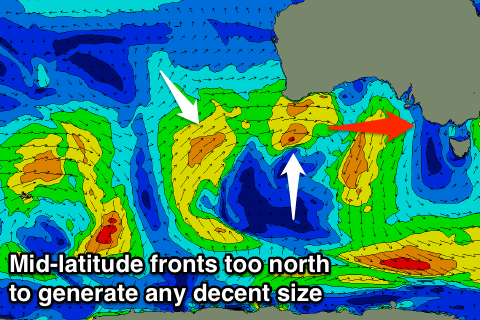
Average westerly swells with poor winds for exposed breaks
Victoria Forecast by Craig Brokensha (issued Friday 21st July)
Best Days: Monday and Tuesday Surf Coast
Recap
Poor conditions continued yesterday across most spots with workable W/SW winds on the Surf Coast for keen surfers and a building S/SW swell. A ridge of high pressure has moved in this morning creating cleaner and improving conditions with fun easing sets from 3-4ft on the Surf Coast and 4-6ft on the Mornington Peninsula.
This weekend and next week (Jul 22 - 28)
The strong polar front responsible for yesterday's and today's S/SW groundswell moved off to the east overnight, resulting in a dropping swell today, further tonight, leaving tiny waves on the Surf Coast tomorrow morning. You may find the stray 1-2ft set but it'll quickly fade under strengthening N/NW winds.
 The Mornington Peninsula may see stray 2-3ft sets but the strengthening N'ly tending N/NW breeze will create average and deteriorating conditions.
As talked about through the week, some new long-period W'ly swell showing on the charts for Saturday was produced by an intense mid-latitude low sitting off WA, too far north of our swell window.
A secondary small pulse of W'ly swell is due Sunday morning from a weak mid-latitude front passing under WA this afternoon and evening, but again only a fetch of patchy W/SW winds will be generated while being poorly positioned in our swell window.
This swell will fail to impact the Surf Coast, with possibly 2-3ft sets on the Mornington Peninsula, while a secondary weak mid-latitude front approaching from the west during the day should produce a slightly bigger increase in W'ly swell into the late afternoon.
Swell magnets on the Surf Coast may see 1-1.5ft sets later in the day, with 3ft+ waves on the Mornington Peninsula but fresh NW tending W/NW winds, which isn't favourable at all for exposed breaks.
It's worth noting out models are over-forecasting the size from these W'ly swells, and in summary, the weekend isn't looking favourable at all for surfing.
Later Sunday's weak pulse of W'ly swell will fade back into Monday, but a small fun pulse of mid-period S/SW swell is due, generated by a funky trough moving developing south-west of Tassie tomorrow.
 A weirdly aligned fetch of strong S/SW winds should produce 2ft sets across the Surf Coast Monday with 3-4ft waves on the Mornington Peninsula. A NW breeze will continued to favour the Surf Coast though.
As touched on last update, a stronger polar low should form in our southern swell window Sunday, generating a fetch of W/SW gales. While not amazing, the Surf Coast is expected to see 3ft sets when the S/SW groundswell peaks Tuesday morning, with 4-5ft waves on the Mornington Peninsula.
Gusty NW tending W/NW winds will only favour the Surf Coast again as yet another mid-latitude front pushes in from the west, kicking up some weak W'ly swell for the afternoon. This swell isn't expected to be above the S/SW groundswell at this stage, with it fading through Wednesday.
Longer term we'll continue to see mid-latitude fronts firing up towards WA and then weakening once tracking towards us, but more on this Monday. Have a great weekend!

