Friday looking best for the period
Victoria Forecast by Craig Brokensha (issued Wednesday 19th July)
Best Days: Both coasts Friday
Recap
A new inconsistent W/SW groundswell filled in yesterday offering 2ft sets at swell magnets on the Surf Coast with all day offshores, while the Mornington Peninsula saw workable 2-3ft waves early before winds swung to the west.
Today a strong onshore change has moved through and we're now seeing a building S/SW windswell across the coast.
This week and weekend (Jul 20 - 23)
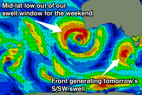
Today's change should kick up 3-4ft of S/SW windswell across the Surf Coast through this afternoon with 4-6ft waves on the Mornington Peninsula, but a secondary stronger polar front projecting towards us will generate a stronger and larger mid-period S/SW swell for tomorrow.
We'll see the Surf Coast building to 4-6ft through the late morning/afternoon and 6ft+ on the Mornington Peninsula with the southerly swell direction, but most locations will remain a mess with fresh to strong SW winds.
 The Torquay region is now more than likely to see an early W'ly wind, creating OK but still raw conditions across the protected reefs. The swell should be in the 4-5ft range through the morning.
Friday is still the day to surf as a ridge of high pressure moves in overnight Thursday, resulting in light N'ly winds (tending N/NW on the Surf Coast). This will create good conditions as the S/SW swell eases from 3ft+ on the Surf Coast and 4-5ft on the Mornington Peninsula.
Into Saturday the Surf Coast is expected to become tiny with a small acute W'ly swell, while the Mornington Peninsula is due to see easing 2-3ft sets. Fresh N/NW winds won't really favour anywhere with the small easing swell.
As touched on in Monday's notes, into Sunday and Monday we should see some new W'ly swell.
This swell won't be favourable at all for the Surf Coast and our models are struggling to capture this, with an incorrect jump in size seen through Sunday afternoon and Monday.
Currently an intense mid-latitude low is sitting off WA, but it's too far north to generate any swell for us, even though the models are showing long-period swell energy hitting the coast.
This low will track east while weakening, with a a secondary mid-latitude front due to move in from the west, just within our swell window Saturday evening and Sunday morning.
A strong fetch of W/NW winds should produce some small but very acute W'ly swell for Sunday afternoon, not budging above 1-1.5ft on the Surf Coast late in the day with possibly 2-3ft sets on the Mornington Peninsula but with gusty W/NW winds.
The weak W'ly swell is due to ease into Monday as winds persist from the west, which isn't ideal at all.
Longer term a polar low forming to the south-west of Tassie may generate a good S/SW groundswell for Tuesday, but we'll have another look at this Friday.

