Great waves with good winds and lots of swell
Victoria Forecast by Craig Brokensha (issued Wednesday 19th April)
Best Days: Both coasts every day of the coming period
Recap
Light winds and moderate amounts of swell yesterday morning, becoming larger into the mid-late afternoon with the arrival of a strong new W/SW groundswell. The Surf Coast pulsed to 4-6ft with workable light winds, and the Mornington Peninsula saw large clean 6-8ft sets.
This morning the larger but slightly less consistent SW groundswell was filling in, coming in at 5-6ft on the Surf Coast and 8ft+ on the Mornington Peninsula. Conditions were much better than expected on the Surf Coast with a variable wind and fog developing across the coast, while the Mornington Peninsula was clean with the offshore breeze. Larger sets have now been seen across both coasts as the swell peaks.
The swell peaked mid-morning on the Cape Sorell buoy, and with a 3-4 hour travel time to the Victorian coast, we should see the swell remaining large into the early afternoon before easing late.
A touch bumpy but no crowds at 6ft+ Winki this morning. Shot by Ben Matson

This week and weekend (Apr 20 - 23)
Today's large and powerful SW groundswell will ease off into this afternoon and evening, dropping further through tomorrow.
Swell magnets on the Surf Coast should see 3-5ft sets, with 6ft sets on the Mornington Peninsula. Winds look great for the beaches with a moderate to fresh N/NE breeze east of Melbourne (N'ly on the Surf Coast and likely N/NW at periods through the morning). Selected reefs will be great, while others wind affected.
Friday morning will be smaller and back to 2-3ft on the Surf Coast and the 4-5ft range on the Mornington Peninsula, with local offshore winds ahead of more variable breezes into the afternoon.
The first in a series of new W/SW swells is still due to kick into the afternoon across the state, but more so later rather than earlier.
This swell has been generated by a good mid-latitude front firing up towards the South West of WA, in our western swell window, with a kick to 3ft+ expected at swell magnets on the Surf Coast and 4-6ft on the Mornington Peninsula.
A slight drop in size back from 3ft and 4-5ft+ is due Saturday morning as favourable conditions are again seen on both coasts with local offshore breezes.
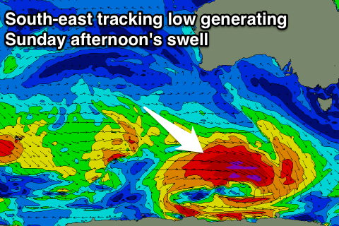
 Into later Saturday and more so Sunday another W/SW groundswell is due, followed by the strongest pulse into the afternoon.
These swells will be generated by back to back mid-latitude fronts projecting towards WA, with the secondary front being strongest and continuing to generate severe-gale W/SW winds in our swell window as it dips south-east under the country.
The first swell for later Saturday and early Sunday looks to come in around 2-3ft on the Surf Coast and 4-5ft on the Mornington Peninsula, while the better and stronger pulse into should arrive late morning and build to an easy 3-4ft and 6ft respectively (if not for the odd larger one at magnets on the Surf Coast).
Conditions look great again with local offshores Sunday morning ahead of sea breezes and a late shallow change through the afternoon.
Monday is looking dicey as the swell eases with lingering S/SE winds on the coast, more variable Tuesday morning.
Longer term there's plenty more swell to come with persistent strong polar frontal activity over the weekend and early next week, but more on this Friday.


Comments
How many goats where sacrificed for this i wonder
Ha, see a bit of action going down on the Peninsula today?
Alex was around.
That he was, and also another mate.
Is that mick? I think we met him at K.I a couple years back.
Yeah, small world ha!
Definatly. Only two degrees of separation on Peninsula.
Craig/Ben
Are we still looking at having n/ne in the winds early sat/sun. Models seem to have it swinging w/sw now....
Thanks
Hi Sarge,
Winds are a little tricky with a weak trough meandering in from the west.
Looks light light N'ly winds Saturday morning, more variable Sunday morning. We'll have a clearer idea tomorrow when we're closer to the weekend and the models resolve the trough more accurately.
Thank you!
Yeah interested to know to, a lot of different forcasts floating around.
What would you say west of mornington?
Cheers
Port Phillip Bay