Great week and weekend ahead
Victoria Forecast by Craig Brokensha (issued Monday 17th April)
Best Days: Surf Coast early Tuesday, east of Melbourne Tuesday morning, beaches Wednesday, both coasts Friday, Saturday and Sunday mornings
Recap
Great surf all weekend with a building W/SW groundswell Saturday, holding into yesterday morning ahead of a secondary kick out of the SW into the afternoon. Conditions have been great on the Surf Coast with variable winds. A little lumpier but still nice to the east.
Today the SW groundswell seen into yesterday afternoon is still providing good sets, while a reinforcing W/SW swell will keep plenty of swell persisting all day.
This week (Apr 18 - 21)
After an excellent run of waves across the Surf Coast, we'll see winds become a little less favourable for the reefs over the coming days (more so Wednesday) with Tuesday and Thursday being actually quite fun.
Today's mix of easing SW groundswell and reinforcing W/SW swell will drop temporarily into tomorrow morning ahead of a strong pulse of W/SW groundswell into the afternoon.
This swell has been generated by a great pre-frontal fetch of severe-gale W/NW winds ahead of the stronger storm-force fetch linked to Wednesday's swell.
 But coming back tomorrow and we should see 3ft to occasionally 4ft waves on the Surf Coast tomorrow morning (5-6ft on the Mornington Peninsula) pulsing to 4-5ft on the sets and 6ft+ respectively through the afternoon with the new W/SW swell.
A light variable wind is expected through the early morning, tending E/NE through the mid-morning ahead of SE sea breezes. This will favour locations east of Melbourne over the Surf Coast.
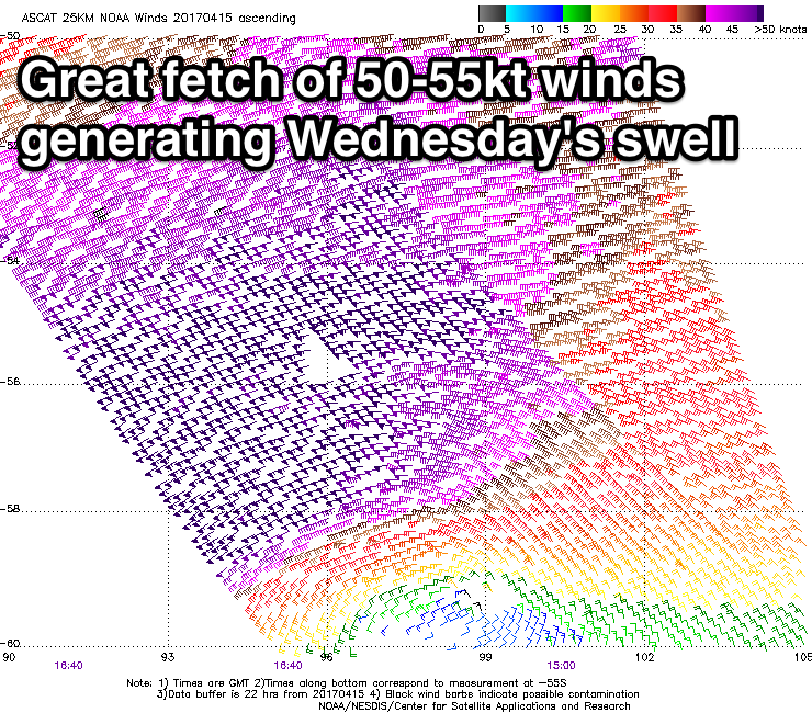
Wednesday's large long-period SW groundswell is on track, with satellite observations confirming an amazing fetch of 50-55kt winds over an already active sea state.
The swell is due to arrive around dawn and peak through the day with 5-6ft waves on the Surf Coast (bigger bombs at swell magnets) and 8ft+ on the Mornington Peninsula.
N/NE winds will limit surfing options with the size of the swell, but the beaches on the Surf Coast should be large and clean, with selected options for experienced riders to the east.
The swell should ease through Thursday and conditions will become good on selected Surf Coast reefs again with a light N/NW offshore breeze (N/NE east of Melbourne), tending variable ahead of possible late sea breezes.
Clean conditions will again be see Friday morning as the swell bottoms out. Into the afternoon a new W/SW groundswell is due, produced by a strong but unfavourably aligned mid-latitude front firing up towards the south of WA today and tomorrow.
A good fetch of gale to severe-gale W'ly winds will be aimed through our western swell window, generating 3-4ft of W/SW groundswell across magnets Friday afternoon on the Surf Coast and 5-6ft on the Mornington Peninsula. By the time this swell kicks though, sea breezes look to create average conditions.
This weekend onwards (Apr 22 onwards)
Friday afternoon's kick in swell is expected to ease through Saturday from a touch smaller size along with light local offshore winds.
Into Sunday a mix of new W/SW groundswells are due to fill in, not too dissimilar in size to Friday afternoon's kick. These swells will be generated by mid-latitude fronts moving through our westerns well window again, with one of them dropping to polar latitudes while strengthening slightly.
A longer-period swell should result to 3-4ft on the Surf Coast and 5-6ft on the Mornington Peninsula under N'ly offshore winds. More on this Wednesday though.


Comments
Lovely lines of new swell, 3-5ft sets at B&W and only a very light onshore breeze. Was glassy for most of the day.
6ft+ Winki with five out.. don't see this often (yeah wind isn't perfect but it's very workable).
Incidentally this is the same wave that JJF hucked the big alley-oop on