Exciting period with lots of swell and varying winds
Victoria Forecast by Craig Brokensha (issued Wednesday 12th April)
Best Days: Both coasts tomorrow, Surf Coast Saturday morning, both coasts Sunday and Monday mornings, Tuesday morning, Wednesday onwards across the Surf Coast
Recap
Poor conditions yesterday with a drop in swell from Monday and no decent surfing options.
Today a new SW groundswell has pulsed back to 3-4ft across the Surf Coast and 5ft on the Mornington Peninsula with variable winds from the east, creating much better conditions across all regions.
We'll see the swell holding all day but SE breezes will develop into the afternoon.
This week and weekend (Apr 13 - 16)
Today's increase in groundswell is a mix of long-range and very inconsistent long-period energy, combined with more consistent mid-range energy.
We should see these swells ease off through tomorrow, dropping back from 3ft+ across swell magnets on the Surf Coast and 4-5ft on the Mornington Peninsula.
Conditions are looking great for both coasts during the morning, with local offshore winds before a more W'ly breeze develops into the early/mid-afternoon ahead of a late W/SW change. The Surf Coast should see a N/NW breeze develop through the morning tomorrow, with N/NE winds on the Mornington Peninsula. Therefore the dawny on the Surf Coast will be better on the beaches, with the reefs improving through the morning.
Come Friday the surf will be smaller and a S/SW change around dawn looks to create poor surfing conditions.
The increase in mid-period W/SW swell due through Friday is still on the cards, produced by a relatively weak mid-latitude front currently passing south of WA.
Of greater importance is the better and stronger W/SW groundswell due Saturday. This is being generated by a stronger fetch of W/SW gales moving in directly behind the mid-latitude front, projecting towards us over the coming days.
The Surf Coast should see this swell fill in around dawn, peaking mid-morning through midday to 3-5ft at swell magnets, with 6ft+ sets on the Mornington Peninsula.
In the wake of Fridays change, a high pressure system will slide in from the west, resulting in variable winds Saturday morning (likely from the W/NW for the Surf Coast) with weak sea breezes. This should create fun waves across most locations west of Melbourne.
A very temporary drop in size is expected Sunday morning across both coasts before a strong new SW groundswell builds through the afternoon.
This swell be a long-period and less consistent swell, generated today and tomorrow by a vigorous polar low developing south-west of WA.
A great fetch of severe-gale to storm-force W/SW winds should produce 3-5ft of inconsistent groundswell for the mid-late afternoon on the Surf Coast with 6ft+ sets on the Mornington Peninsula under light N/NW tending W/SW breezes.
 Next week onwards (April 17 onwards)
Moving into next week and Sunday afternoon's increase in SW swell should drop back slightly and we're again looking at local offshore winds through the morning.
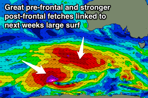
Of greater importance is a vigorous polar frontal progression firing up south-west of the country over the weekend under the influence of the Long Wave Trough.
A very broad and elongated fetch of pre-frontal W/NW gale to severe-gale winds will develop south-west of WA, pushing east under the country through Sunday, generating a strong W/SW groundswell for Tuesday.
The Surf Coast should kick to 4-5ft through the afternoon, with the Mornington Peninsula seeing 6-8ft sets.
A secondary better aligned and stronger trailing fetch of severe-gale W/SW winds should then generate a larger SW groundswell for Wednesday afternoon and Thursday. The size hasn't really changed from Monday, with easy 6ft surf due on the Surf Coast and 8ft waves on the Mornington Peninsula into Wednesday afternoon.
The tricky part is the local winds, with the models still diverging on how high each front will ride through the middle to end of next week.
At this stage it looks like Tuesday will now see N/NE winds, favouring locations east of Melbourne, but they'll be large. A swing back to NW winds is then likely Wednesday with an approaching front, persisting from the western quadrant through the rest of the week.
Check back here on Friday though for a clearer idea on the timing of the swells and local conditions.


Comments
The swell has really kicked up a gear this afternoon. Bells is seeing 4-5ft sets. Looks like that long period energy from the Indian Ocean is really coming in nicely. Tomorrow should be great.
Heading to Bells with the family over the weekend, thoughts on the best day for competition, Saturday or Sunday? Sunday appears to have better winds? Cheers
Both days pretty similar conditions wise, with Sunday likely being a touch straighter and cleaner.
Love your work Swellnet!
Sunday