A fun day for swell magnets tomorrow
Victoria Forecast by Craig Brokensha (issued Wednesday 8th March)
Best Days: Swell magnets tomorrow, Torquay early Friday, east of Melbourne Saturday morning
Recap
Average conditions across all coasts yesterday with strengthening E/SE winds and a building SE windswell across the Surf Coast, mixed in with an inconsistent SW groundswell.
This morning cleaner conditions were seen with a peaky mix of SW and SE swell to 2ft on the Surf Coast (best on the beaches for keen surfers) and 3-4ft on the Mornington Peninsula. We'll see both swells ease with afternoon sea breezes.
This week and weekend (Mar 9 – 12)
Tomorrow is looking nice and clean across the beaches on both coasts with a light N/NE offshore to the east of Melbourne and N/NE tending N/NW breezes to the west.
The swell will be back to 1-1.5ft on the Surf Coast though (likely 1-2ft magnets), while the Mornington Peninsula should see 3ft sets. Sea breezes are only due mid-late afternoon, so a couple of surfs are on the cards at magnets across the state.
Our small new SW groundswell is still due later tomorrow and Friday morning generated by a tight polar low the last couple of days.
The Surf Coast should see fun 2ft+ waves early Friday morning with 3-4ft+ waves on the Mornington Peninsula, but a light to moderate SW'ly will create average conditions. Torquay is likely to see an early W/NW breeze though.
The weekend isn't looking too good at all with Friday's swell continuing to ease from 1-1.5ft on the Surf Coast and 3ft on the Mornington Peninsula with a light morning SE breeze. We may see lighter E'ly breezes east of Melbourne, but we'll have another look at this Friday.
Sunday is looking cleaner with more variable winds but there'll be no decent swell at all.
 Next week onwards (Mar 13 onwards)
Early next week, conditions will remain poor as a surface trough/low forming in the wake of an onshore change later Sunday kicks up small weak amounts of windswell along with onshore winds.
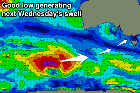
A good long-period SW groundswell is due later Tuesday and Wednesday from a strong polar low firing up south-west of WA over the weekend. The peak of this swell looks to arrive with more favourable but not great E/NE winds, but check back Friday for an update on this.

