Easing surf with some new swell late week
Victoria Forecast by Craig Brokensha (issued Monday 20th February)
Best Days: Surf Coast Tuesday morning, magnets across the state Wednesday morning, possibly dawn on the Surf Coast Friday, east of Melbourne Monday
Recap
Pumping waves most of the weekend on the Surf Coast with a large building W/SW groundswell through Saturday under morning offshores, giving into a shallow change with lighter winds into the late afternoon/evening.
Sunday was excellent with clean 4-6ft surf most of the day on the protected reefs with the arrival of a reinforcing SW swell. East of Melbourne, protected spots were the go all weekend.
Into this morning winds finally took a turn for the worst with the weakening front finally moving across us. Torquay still saw an early W'ly but it wasn't as clean and lined up as the weekend.
The swell was also on the ease from 3-5ft, with messy 6ft+ waves to the west.
This week and weekend (Feb 21 - 26)
We're on a gradual downward trend in swell after the weekend's large pulses and this will continue through tomorrow as morning W/NW breezes favour the Surf Coast again.
Easing 3ft sets are due at magnets (2-3ft most spots) with 4-5ft sets on the Mornington Peninsula, with that light W/NW'ly persisting all morning, variable into the early afternoon ahead of SE sea breezes.
 Wednesday will be the go to the east of Melbourne with small easing 2ft waves (maybe the odd bigger one) under N/NE winds, giving into an evening change. The Surf Coast will be tiny.
Now, into the end of the week and weekend some new W/SW groundswell is due but winds don't look anywhere near as favourable as the weekend just gone.
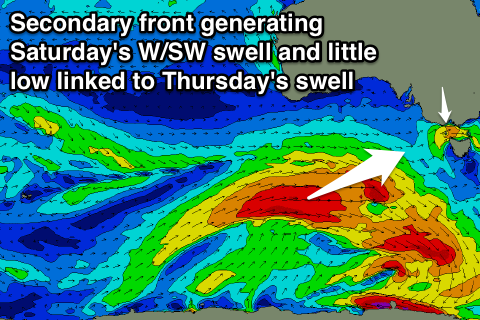
Firstly Thursday a very acute and weak W'ly swell is due from a small tight low producing a fetch of strong W/SW winds through our western swell window overnight and early morning.
The Surf Coast isn't due to see any size with 1-2ft sets max, with onshore 3-4ft waves to the east.
Of greater importance is a strong polar frontal progression forming south-west of WA this evening, with an initial front projecting a fetch of W/SW gales towards us south of the Bight, followed by a secondary push Wednesday and Thursday, weakening slowly Friday.
Two separate pulses of W/SW groundswell are due, the first for Friday, building to a good 3ft on the Surf Coast through the morning (if not a touch bigger through the day) and 5-6ft on the Mornington Peninsula.
The secondary swell is due Saturday, coming in at 3-4ft and 6ft+ respectively before easing slowly Sunday.
Unfortunately winds are expected to go onshore from the SW Friday (possibly W'ly at dawn around Torquay) and then S/SE'ly on Saturday with lighter E/SE breezes Sunday. We'll confirm this on Wednesday though.
Monday looks better to the east of Melbourne with a morning NE'ly, while some new swell is on the cards Tuesday. Check back Wednesday for most on this.

