Plenty of swell for the weekend, good working around the wind
Victoria Forecast by Craig Brokensha (issued Friday 6th May)
Best Days: Saturday morning both coasts, Sunday east of Melbourne, Monday both coasts (Surf Coast early), Wednesday morning keen surfers Surf Coast
Recap
The surf continued to pump at spots handling the swell across most of the state yesterday, with the Surf Coast still providing 6-8ft cleanup sets early, while the Mornington Peninsula was too large, leaving protected spots with the best waves.
A drop in swell was seen through the afternoon and further today back from 3-5ft on the Surf Coast and 6ft+ on the Mornington Peninsula under morning offshores. Winds will swing more more W/NW this afternoon as the swell continues to ease.
This weekend and next week (May 7 - 13)
The swell won't drop below 3ft into tomorrow morning on the Surf Coast and 5-6ft on the Mornington Peninsula, with a new W/SW swell due to build through the day, generated by a frontal system that's currently to our west.
This should see 4ft sets into the afternoon on the Surf Coast and 6ft+ waves on the Mornington Peninsula and conditions should be clean on both coasts during the morning with local offshore winds, tending E/NE into the afternoon.
The swell should ease back from a similar size Sunday morning but fresh and gusty NE tending E/NE winds will favour locations east of Melbourne and selected Surf Coast beaches.
The swell will continue to ease Monday back from 2ft+ on the Surf Coast and 4-5ft on the Mornington Peninsula under local offshore N'ly winds.
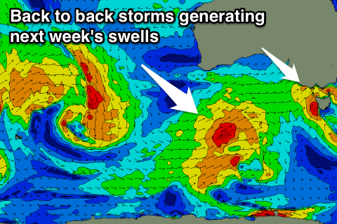
Our next increase in swell will be through Tuesday as a strong and deep mid-latitude low meanders its way east through the Bight and then south-east across us Tuesday,
A burst to gale to severe-gale SW winds will be projected through Bass Strait, generating a stormy increase in SW swell, reaching 3-5ft across the Surf Coast and 6-8ft on the Mornington Peninsula through the afternoon but with strong W/SW winds.
 The low will continue east into the evening resulting in a rapid drop in swell Wednesday from 3ft on the Surf coast and 5-6ft on the Mornington Peninsula as winds swing W/NW.
With no time to gather ourselves, yet another vigorous storm is expected to push into us Wednesday afternoon and evening, but this will be a much broader and stronger frontal system aiming a fetch of gale to severe-gale SW winds towards us.
A late increase in stormy swell is due Wednesday ahead of a peak in groundswell Thursday to 6ft+ and 10ft+ respectively. Conditions will be a mess though with strong SW winds, cleaner and easing Friday.
Longer term there's plenty of fun W/SW swell due from next week onwards as front after front fires up through the Southern Ocean, more on this Monday. Have a great weekend!


Comments
Still the odd bomb at 13th this morning.
And definitely some bombs at Portsea.