Great period for the Surf Coast
Victoria Forecast by Craig Brokensha (issued Wednesday 6th April)
Best Days: Monday both coasts, Tuesday and Wednesday east of Melbourne
Recap
Great conditions across both coasts yesterday with a clean easing 3ft swell on the Surf Coast and 4-5ft on the Mornington Peninsula. Winds remained favourable until mid-afternoon, when a SW change started to move through.
This morning, a new mix of swells are building, with light offshore winds for the Surf Coast and surf in the 3ft range (3-4ft at 13th Beach), while the Mornington Peninsula is a messy and onshore 5-6ft. We should see the swell continuing to build through the day, peaking to 3-4ft across most breaks on the Surf Coast and 6ft+ on the Mornington Peninsula with a midday onshore W/SW change.
This week and weekend (Apr 7 – 10)
Today's building mix of swells is still yet to peak on the Cape Sorell wave buoy (but should soon), and with this, we'll see the swell peak this afternoon/evening before starting to ease back tomorrow.
The Surf Coast should ease back from the 3ft range tomorrow, with 5-6ft sets on the Mornington Peninsula and conditions will be great on the Surf Coast with a moderate to fresh W/NW wind, tending more W'ly into the afternoon but likely holding.
A low point in activity is still due Friday with 2ft+ waves on the Surf Coast (2-3ft 13th Beach) and 4-5ft on the Mornington Peninsula, and NW winds will keep the Surf Coast clean, tending W/NW through the day and then possibly W/SW late.
 Saturday's SW groundswells are still on track, with a couple of strong and back to back polar fronts due to generate the swell over the coming days.
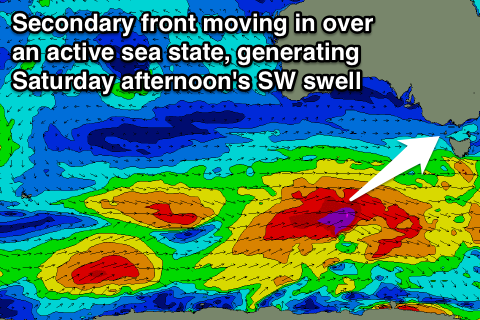
Currently the first system is south of WA, generating a broad and elongated fetch of gale to severe-gale W/SW winds. This will then be overtaken by a secondary slightly stronger but less expansive front.
With the second front moving over the active sea state of the first, we'll see two good SW groundswells generated, arriving only 6 hours apart through Saturday.
The first pulse should fill in around dawn Saturday offering good 3-4ft sets across swell magnets, with the secondary stronger pulse filling in through the middle of the day, peaking into the afternoon to 4-5ft.
The Mornington Peninsula should build from 5-6ft+ through the morning, to a larger 6-8ft+ into the afternoon.
Conditions are looking great all day on the Surf Coast and good early on the Mornington Peninsula with an offshore N/NW tending W/NW and then variable wind west of Melbourne and N'ly tending W/NW breeze to the east.
The swell will drop temporarily into Sunday likely from 3-4ft on the Surf Coast and 6ft+ on the Mornington Peninsula and strengthening NW winds ahead of a strong afternoon W/SW change will again favour the Surf Coast.
This change will be linked to a flurry of secondary polar frontal activity through the same part of our swell window the initial activity will move through.
The strength and size of the progression looks similar, but the secondary front will push right up and through Bass Strait Sunday afternoon while producing severe-gale SW winds.
A late increase in short-rage and stronger SW groundswell are due from this change Sunday, with the groundswell peaking Monday morning to 4-6ft on the Surf Coast and 8ft on the Mornington Peninsula.
Conditions will be average though with a strong and easing SW breeze, with only a slim chance for an early W'ly around Torquay.
Tuesday should see a better chance for a morning W/NW'ly on the Surf Coast as the swell eases.
Longer term, another strong pulse of S/SW groundswell is due for Wednesday across the state, but winds will be poor and onshore from the S'th as a building ridge of high pressure moves in from the west. More on this Friday.


Comments
Is it just me or is this winter going to be good again for the weekend warrior. Last 2 big swells have fallen on the weekend and a nice offshore swell last Friday. Again this weekend it will be best on the weekend and during the week there will be swell but on onshore. Feels like this could be a very good winter
Surf report this morning: Waves at 'Gary's' on the surf coast (as I like to call it) were 1 Gary with the occasional 2 Gary rogue set.
Conditions were as clean as the bench press after my work out, with lines stacked to the horizon like the legions of Gary-Imitators.
hi guys
does it still look to be strong wnw winds before the cold front on sunday….on the animated met eye and marine forecast on the bom the cold front looks just south of bass straight….on the thursday update.
im a keen wave sailer just wanting a different opinion as the forecast looks dicy as of tonight….
Looking fresh and gusty for me, easy 15-20kt offshore from the coast, stronger into Bass Strait.
no problem! thanks for the reply!
looking forward to your friday forecast (: