Tricky week, best to the east, more action from Sunday
Victoria Forecast by Craig Brokensha (issued Monday 12th October)
Best Days: Wednesday through Friday east of Melbourne, Sunday Surf Coast
Recap
Fun waves across exposed breaks Saturday with clean 2-3ft sets at swell magnets on the Surf Coast and 4-5ft waves on the Mornington Peninsula with favourable winds most of the day.
Sunday was smaller and winds were only favourable around dawn before a weak onshore change moved through, creating less than ideal conditions.
Today the surf was bumpy with a weak onshore wind and new small kick in W/SW swell, providing some motivation to head off to work or school instead of missing out on any decent surf.
This week (Oct 13 – 16)
This afternoon a fresher S/SW change is due across the region as a surface trough drifts in from the west. The trough is expected to weaken into tomorrow morning, but the models diverge on whether we'll see a lingering onshore wind. The American solution has lighter and more variable breezes, while the European version has weaker S/SE breezes. I think we'll see something in between with light to moderate and lingering S/SE winds through the morning tomorrow, increasing a touch through the afternoon.
In any case, today's swell will be on the ease from 2ft in Torquay and 3-4ft on the Mornington Peninsula.
Wednesday will be much better at swell magnets east of Melbourne as winds swing offshore from the N/NE, but the surf will be small and around 3ft or so on the sets.
Come Thursday local offshore winds (N/NW Surf Coast and N/NE Mornington Peninsula) should create clean conditions, with the arrival of a new inconsistent W/SW groundswell.
This groundswell will be very inconsistent, generated by a fetch of weakening W/NW gales in our far swell window in the southern Indian Ocean the last couple of days. Exposed spots on the Surf Coast should see 2ft sets, with the Mornington Peninsula a better bet with 3-4ft waves with 5ft bombs. Winds may tend more N/NW east of Melbourne through the late afternoon as the swell eases a little, so try and get out before then.
Into Friday a new pulse of SW groundswell is due, but from a less than favourably aligned and tracking front and deepening low under the country on Wednesday. A small and short-lived fetch of gale to severe-gale W/SW winds will be generated in our swell window, kicking up a short-lived pulse of SW swell for Friday. Only small 2ft+ waves are due across the Surf Coast with 3-4ft sets on the Mornington Peninsula, easing into Saturday (mixed in with a very very inconsistent and small long-range W/SW groundswell from under South Africa).
Winds on Friday look to be variable again ahead of a shallow SW change, with Saturday a little unsure at this stage.
 This weekend onwards (Oct 17 onwards)
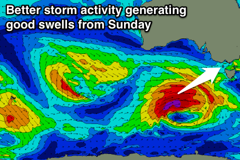
We're finally looking at a bit more action across the region from this weekend as a couple of strong and favourably tracking lows push in from the west under the influence of the Long Wave Trough.
The first of these is expected to produce a moderate sized W/SW groundswell for Sunday coming in around 3-4ft+ on the Surf Coast and 6-8ft on the Mornington Peninsula under NW to SW winds. A secondary pulse is then due around Tuesday, but we'll have another look at this on Wednesday.


Comments
Hey Craig, hope you got some waves on the weekend nailed the forecast !
Once again for SW Vic, WAMS has winds on Wednesday morning going SE, then going back to NE do you think this is likely ? I've noticed that winds sometimes act differently here to the surfcoast and eastern vic, what pattern causes this local effect ? Would be killer if it just stayed NE all morning. Yew thanks !!
Superfish, the time-stamp is sometimes a little off on the WAMs by 6 or so hours, but looking at great N/NE winds all morning, tending variable ahead of a weak and mid-late aftenoon sea breeze.
Hi Sorrento!
**waves**
I guess just like Gary, you're watching from somewhere unseen. Seems you and I have more in common that we both first thought....