Average weekend, better Monday
Victoria Forecast by Craig Brokensha (issued Friday 28th August)
Best Days: Monday both coasts, Tuesday and Wednesday east of Melbourne
Recap
Finally a window of cleaner conditions across the Surf Coast yesterday with a variable tending light offshore wind and clean 3-4ft of swell. The Mornington Peninsula was bigger but a bit bumpy with the light to moderate W'ly breeze. A developing onshore during the middle of the day created deteriorating conditions for the rest of the day.
Today the SW groundswell was easing with fresh onshore winds, creating poor conditions across both coasts.
This weekend and next week (Aug 29 – Sep 4)
There'll be no love over the weekend with onshore winds expected to pick up a notch through tomorrow with smaller amounts of swell and a strengthening S/SW breeze. This will also kick up moderate amounts of S/SW windswell through the afternoon, easing through Sunday as a new long-range SW groundswell fills in but with fresh and weakening S'ly tending S/SE winds.
There's been no change to the stronger secondary long-range SW groundswell due to peak Monday morning with infrequent 3ft+ sets due across the Surf Coast with 5-6ft+ waves on the Mornington Peninsula with variable breezes, creating clean conditions across both coasts.
 Tuesday will be smaller and best east of Melbourne with N/NE tending E'ly winds.
Wednesday should hold a similar size to Wednesday with background levels of swell and NE winds, favouring the Mornington Peninsula again.
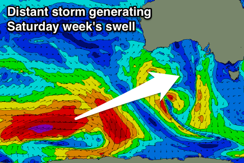
Longer term a new long-range SW groundswell is due to build Friday afternoon and peak Saturday, again generated in our far swell window in the Indian Ocean, south-west of WA.
Only an inconsistent 3ft or so of swell is due across the Surf Coast with 6ft sets on the Mornington Peninsula but with average S/SE winds. More on this Monday though. Have a great weekend!

